You are here: Home > Network List > YT07 - POLENET Stations List
> Station CLRK CLRK > Earthquake Result Viewer
CLRK CLRK - Earthquake Result Viewer
| Earthquake location: |
Solomon Islands |
| Earthquake latitude/longitude: |
-9.8/160.3 |
| Earthquake time(UTC): |
2015/05/21 (141) 19:32:57 GMT |
| Earthquake Depth: |
10 km |
| Earthquake Magnitude: |
6.0 MWB |
| Earthquake Catalog/Contributor: |
NEIC PDE/NEIC COMCAT |
|
| Network: |
YT POLENET |
| Station: |
CLRK CLRK |
| Lat/Lon: |
77.32 S/141.85 W |
| Elevation: |
1043 m |
|
| Distance: |
73.7 deg |
| Az: |
168.77 deg |
| Baz: |
299.64 deg |
| Ray Param: |
0.052821465 |
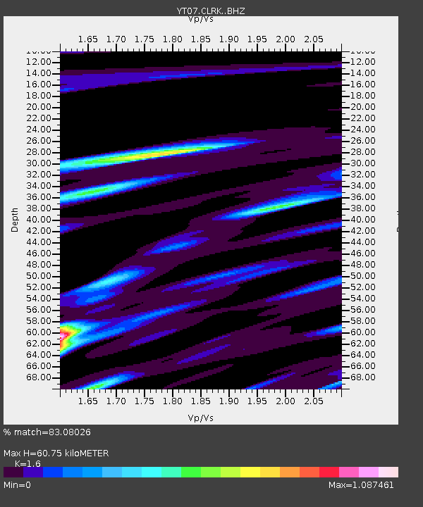
| Estimated Moho Depth: |
60.75 km |
| Estimated Crust Vp/Vs: |
1.60 |
| Assumed Crust Vp: |
6.182 km/s |
| Estimated Crust Vs: |
3.863 km/s |
| Estimated Crust Poisson's Ratio: |
0.18 |
|
| Radial Match: |
83.08026 % |
| Radial Bump: |
400 |
| Transverse Match: |
47.158535 % |
| Transverse Bump: |
398 |
| SOD ConfigId: |
7422571 |
| Insert Time: |
2019-04-19 00:14:08.000 +0000 |
| GWidth: |
2.5 |
| Max Bumps: |
400 |
| Tol: |
0.001 |
|

Signal To Noise
| Channel | StoN | STA | LTA |
| YT:CLRK: :BHZ:20150521T19:43:59.449971Z | 5.6110077 | 4.5790003E-7 | 8.1607446E-8 |
| YT:CLRK: :BHN:20150521T19:43:59.449971Z | 2.2571697 | 1.498697E-7 | 6.6397185E-8 |
| YT:CLRK: :BHE:20150521T19:43:59.449971Z | 1.7579587 | 1.6748811E-7 | 9.52742E-8 |
| Arrivals |
| Ps | 6.1 SECOND |
| PpPs | 25 SECOND |
| PsPs/PpSs | 31 SECOND |


