You are here: Home > Network List > IU - Global Seismograph Network (GSN - IRIS/USGS) Stations List
> Station PMG Port Moresby, New Guinea > Earthquake Result Viewer
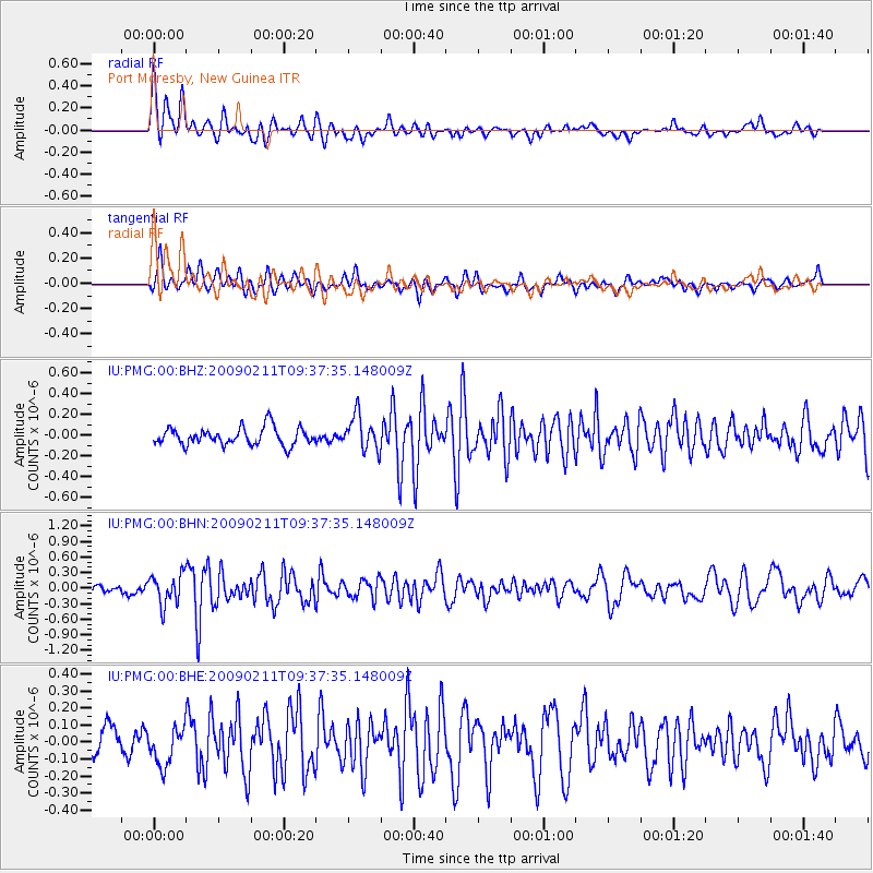
PMG Port Moresby, New Guinea - Earthquake Result Viewer
*The percent match for this event was below the threshold and hence no stack was calculated.
| Earthquake location: |
Fiji Islands Region |
| Earthquake latitude/longitude: |
-20.8/-177.3 |
| Earthquake time(UTC): |
2009/02/11 (042) 09:31:04 GMT |
| Earthquake Depth: |
10 km |
| Earthquake Magnitude: |
5.5 MB, 5.2 MS, 5.5 MW, 5.5 MW |
| Earthquake Catalog/Contributor: |
WHDF/NEIC |
|
| Network: |
IU Global Seismograph Network (GSN - IRIS/USGS) |
| Station: |
PMG Port Moresby, New Guinea |
| Lat/Lon: |
9.41 S/147.15 E |
| Elevation: |
67 m |
|
| Distance: |
36.0 deg |
| Az: |
282.873 deg |
| Baz: |
112.404 deg |
| Ray Param: |
$rayparam |
*The percent match for this event was below the threshold and hence was not used in the summary stack. |
|
| Radial Match: |
84.147766 % |
| Radial Bump: |
400 |
| Transverse Match: |
72.365814 % |
| Transverse Bump: |
400 |
| SOD ConfigId: |
2658 |
| Insert Time: |
2010-03-02 15:18:40.920 +0000 |
| GWidth: |
2.5 |
| Max Bumps: |
400 |
| Tol: |
0.001 |
|
Signal To Noise
| Channel | StoN | STA | LTA |
| IU:PMG:00:BHN:20090211T09:37:35.148009Z | 3.2319684 | 2.8742622E-7 | 8.8932254E-8 |
| IU:PMG:00:BHE:20090211T09:37:35.148009Z | 1.2535172 | 1.0836862E-7 | 8.645164E-8 |
| IU:PMG:00:BHZ:20090211T09:37:35.148009Z | 1.9282889 | 1.6364388E-7 | 8.4864816E-8 |
| Arrivals |
| Ps | |
| PpPs | |
| PsPs/PpSs | |


