You are here: Home > Network List > IU - Global Seismograph Network (GSN - IRIS/USGS) Stations List
> Station PMG Port Moresby, New Guinea > Earthquake Result Viewer
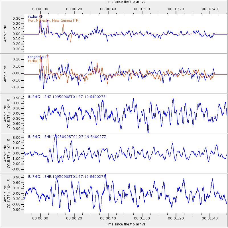
PMG Port Moresby, New Guinea - Earthquake Result Viewer
*The percent match for this event was below the threshold and hence no stack was calculated.
| Earthquake location: |
Southern East Pacific Rise |
| Earthquake latitude/longitude: |
-56.2/-122.4 |
| Earthquake time(UTC): |
1995/09/08 (251) 01:15:28 GMT |
| Earthquake Depth: |
10 km |
| Earthquake Magnitude: |
5.2 MB, 6.3 MS, 6.3 UNKNOWN, 6.3 MW |
| Earthquake Catalog/Contributor: |
WHDF/NEIC |
|
| Network: |
IU Global Seismograph Network (GSN - IRIS/USGS) |
| Station: |
PMG Port Moresby, New Guinea |
| Lat/Lon: |
9.41 S/147.15 E |
| Elevation: |
67 m |
|
| Distance: |
82.5 deg |
| Az: |
264.359 deg |
| Baz: |
145.656 deg |
| Ray Param: |
$rayparam |
*The percent match for this event was below the threshold and hence was not used in the summary stack. |
|
| Radial Match: |
71.143326 % |
| Radial Bump: |
400 |
| Transverse Match: |
72.42829 % |
| Transverse Bump: |
400 |
| SOD ConfigId: |
4480 |
| Insert Time: |
2010-03-02 15:18:42.680 +0000 |
| GWidth: |
2.5 |
| Max Bumps: |
400 |
| Tol: |
0.001 |
|
Signal To Noise
| Channel | StoN | STA | LTA |
| IU:PMG: :BHN:19950908T01:27:19.640027Z | 3.6235433 | 6.1886504E-7 | 1.7079002E-7 |
| IU:PMG: :BHE:19950908T01:27:19.640027Z | 0.8159563 | 1.7984854E-7 | 2.2041444E-7 |
| IU:PMG: :BHZ:19950908T01:27:19.640027Z | 1.3019155 | 3.238708E-7 | 2.4876485E-7 |
| Arrivals |
| Ps | |
| PpPs | |
| PsPs/PpSs | |


