You are here: Home > Network List > IU - Global Seismograph Network (GSN - IRIS/USGS) Stations List
> Station PMG Port Moresby, New Guinea > Earthquake Result Viewer
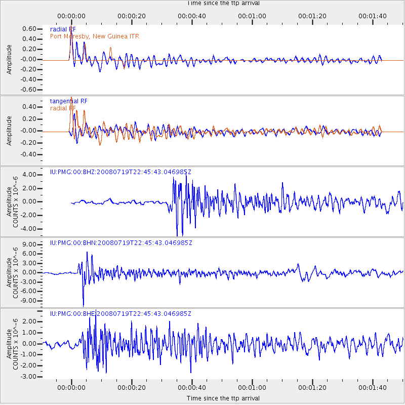
PMG Port Moresby, New Guinea - Earthquake Result Viewer
*The percent match for this event was below the threshold and hence no stack was calculated.
| Earthquake location: |
Fiji Islands Region |
| Earthquake latitude/longitude: |
-17.3/-177.3 |
| Earthquake time(UTC): |
2008/07/19 (201) 22:39:52 GMT |
| Earthquake Depth: |
391 km |
| Earthquake Magnitude: |
5.9 MB, 6.4 MW, 6.4 MW |
| Earthquake Catalog/Contributor: |
WHDF/NEIC |
|
| Network: |
IU Global Seismograph Network (GSN - IRIS/USGS) |
| Station: |
PMG Port Moresby, New Guinea |
| Lat/Lon: |
9.41 S/147.15 E |
| Elevation: |
67 m |
|
| Distance: |
35.4 deg |
| Az: |
278.204 deg |
| Baz: |
106.648 deg |
| Ray Param: |
$rayparam |
*The percent match for this event was below the threshold and hence was not used in the summary stack. |
|
| Radial Match: |
87.905136 % |
| Radial Bump: |
400 |
| Transverse Match: |
79.17016 % |
| Transverse Bump: |
400 |
| SOD ConfigId: |
2504 |
| Insert Time: |
2010-03-02 15:18:44.050 +0000 |
| GWidth: |
2.5 |
| Max Bumps: |
400 |
| Tol: |
0.001 |
|
Signal To Noise
| Channel | StoN | STA | LTA |
| IU:PMG:00:BHN:20080719T22:45:43.046985Z | 10.466499 | 2.7721917E-6 | 2.6486333E-7 |
| IU:PMG:00:BHE:20080719T22:45:43.046985Z | 2.8454175 | 4.8042614E-7 | 1.6884205E-7 |
| IU:PMG:00:BHZ:20080719T22:45:43.046985Z | 6.6226306 | 1.1961307E-6 | 1.8061262E-7 |
| Arrivals |
| Ps | |
| PpPs | |
| PsPs/PpSs | |


