You are here: Home > Network List > CN - Canadian National Seismograph Network Stations List
> Station INK INUVIK, NT > Earthquake Result Viewer
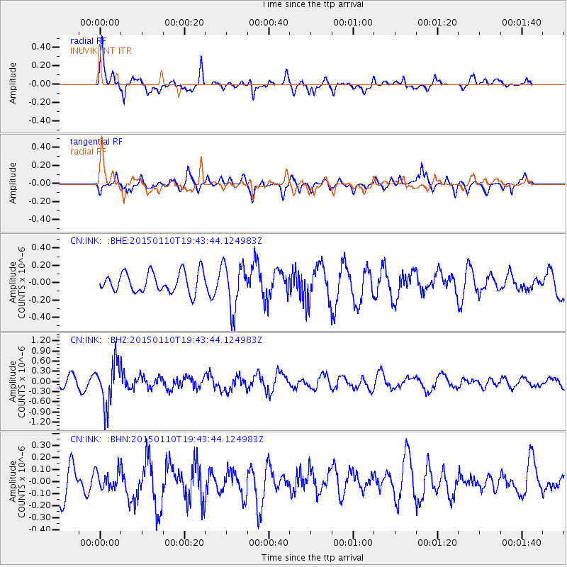
INK INUVIK, NT - Earthquake Result Viewer
*The percent match for this event was below the threshold and hence no stack was calculated.
| Earthquake location: |
Luzon, Philippines |
| Earthquake latitude/longitude: |
14.8/120.3 |
| Earthquake time(UTC): |
2015/01/10 (010) 19:32:02 GMT |
| Earthquake Depth: |
75 km |
| Earthquake Magnitude: |
5.8 MWB |
| Earthquake Catalog/Contributor: |
NEIC PDE/NEIC COMCAT |
|
| Network: |
CN Canadian National Seismograph Network |
| Station: |
INK INUVIK, NT |
| Lat/Lon: |
68.31 N/133.53 W |
| Elevation: |
44 m |
|
| Distance: |
82.2 deg |
| Az: |
21.12 deg |
| Baz: |
290.356 deg |
| Ray Param: |
$rayparam |
*The percent match for this event was below the threshold and hence was not used in the summary stack. |
|
| Radial Match: |
66.04527 % |
| Radial Bump: |
382 |
| Transverse Match: |
55.736176 % |
| Transverse Bump: |
400 |
| SOD ConfigId: |
828811 |
| Insert Time: |
2015-01-24 19:50:54.861 +0000 |
| GWidth: |
2.5 |
| Max Bumps: |
400 |
| Tol: |
0.001 |
|
Signal To Noise
| Channel | StoN | STA | LTA |
| CN:INK: :BHZ:20150110T19:43:44.124983Z | 5.177785 | 6.338375E-7 | 1.2241479E-7 |
| CN:INK: :BHN:20150110T19:43:44.124983Z | 0.59625894 | 7.249531E-8 | 1.2158361E-7 |
| CN:INK: :BHE:20150110T19:43:44.124983Z | 2.3217547 | 2.676841E-7 | 1.1529388E-7 |
| Arrivals |
| Ps | |
| PpPs | |
| PsPs/PpSs | |


