You are here: Home > Network List > IU - Global Seismograph Network (GSN - IRIS/USGS) Stations List
> Station PMG Port Moresby, New Guinea > Earthquake Result Viewer
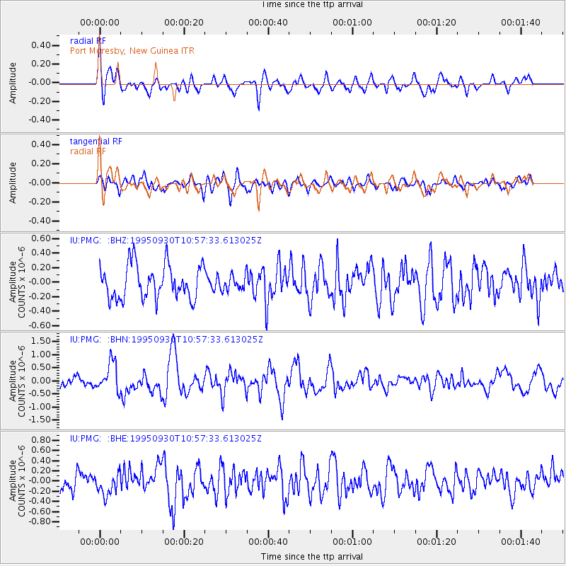
PMG Port Moresby, New Guinea - Earthquake Result Viewer
*The percent match for this event was below the threshold and hence no stack was calculated.
| Earthquake location: |
Kuril Islands |
| Earthquake latitude/longitude: |
50.8/157.4 |
| Earthquake time(UTC): |
1995/09/30 (273) 10:47:56 GMT |
| Earthquake Depth: |
33 km |
| Earthquake Magnitude: |
5.7 MB, 5.5 MS |
| Earthquake Catalog/Contributor: |
WHDF/NEIC |
|
| Network: |
IU Global Seismograph Network (GSN - IRIS/USGS) |
| Station: |
PMG Port Moresby, New Guinea |
| Lat/Lon: |
9.41 S/147.15 E |
| Elevation: |
67 m |
|
| Distance: |
60.6 deg |
| Az: |
191.593 deg |
| Baz: |
7.422 deg |
| Ray Param: |
$rayparam |
*The percent match for this event was below the threshold and hence was not used in the summary stack. |
|
| Radial Match: |
69.96076 % |
| Radial Bump: |
400 |
| Transverse Match: |
60.338375 % |
| Transverse Bump: |
400 |
| SOD ConfigId: |
4480 |
| Insert Time: |
2010-03-02 15:18:51.377 +0000 |
| GWidth: |
2.5 |
| Max Bumps: |
400 |
| Tol: |
0.001 |
|
Signal To Noise
| Channel | StoN | STA | LTA |
| IU:PMG: :BHN:19950930T10:57:33.613025Z | 3.3358295 | 5.672952E-7 | 1.7006121E-7 |
| IU:PMG: :BHE:19950930T10:57:33.613025Z | 1.127265 | 2.153085E-7 | 1.9100078E-7 |
| IU:PMG: :BHZ:19950930T10:57:33.613025Z | 0.44622752 | 1.0342793E-7 | 2.3178295E-7 |
| Arrivals |
| Ps | |
| PpPs | |
| PsPs/PpSs | |


