You are here: Home > Network List > IU - Global Seismograph Network (GSN - IRIS/USGS) Stations List
> Station PMG Port Moresby, New Guinea > Earthquake Result Viewer
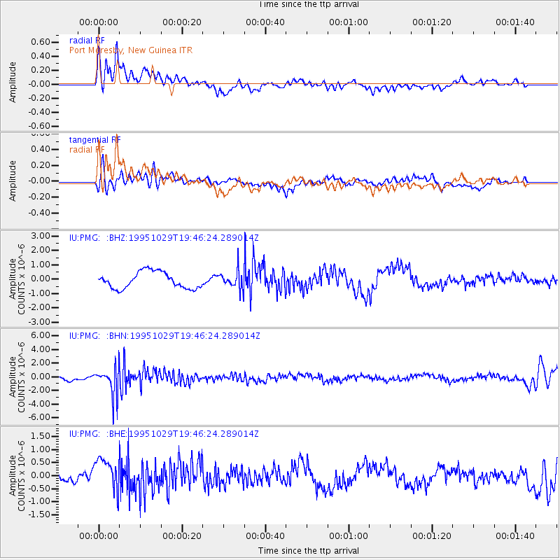
PMG Port Moresby, New Guinea - Earthquake Result Viewer
*The percent match for this event was below the threshold and hence no stack was calculated.
| Earthquake location: |
Fiji Islands Region |
| Earthquake latitude/longitude: |
-21.7/-179.5 |
| Earthquake time(UTC): |
1995/10/29 (302) 19:40:57 GMT |
| Earthquake Depth: |
611 km |
| Earthquake Magnitude: |
5.7 MB, 6.1 UNKNOWN |
| Earthquake Catalog/Contributor: |
WHDF/NEIC |
|
| Network: |
IU Global Seismograph Network (GSN - IRIS/USGS) |
| Station: |
PMG Port Moresby, New Guinea |
| Lat/Lon: |
9.41 S/147.15 E |
| Elevation: |
67 m |
|
| Distance: |
34.3 deg |
| Az: |
285.639 deg |
| Baz: |
114.826 deg |
| Ray Param: |
$rayparam |
*The percent match for this event was below the threshold and hence was not used in the summary stack. |
|
| Radial Match: |
78.681656 % |
| Radial Bump: |
400 |
| Transverse Match: |
65.80065 % |
| Transverse Bump: |
400 |
| SOD ConfigId: |
4480 |
| Insert Time: |
2010-03-02 15:19:03.814 +0000 |
| GWidth: |
2.5 |
| Max Bumps: |
400 |
| Tol: |
0.001 |
|
Signal To Noise
| Channel | StoN | STA | LTA |
| IU:PMG: :BHN:19951029T19:46:24.289014Z | 4.340272 | 2.1523676E-6 | 4.959062E-7 |
| IU:PMG: :BHE:19951029T19:46:24.289014Z | 2.566614 | 6.238428E-7 | 2.4306064E-7 |
| IU:PMG: :BHZ:19951029T19:46:24.289014Z | 1.0822369 | 6.144471E-7 | 5.6775656E-7 |
| Arrivals |
| Ps | |
| PpPs | |
| PsPs/PpSs | |


