You are here: Home > Network List > IU - Global Seismograph Network (GSN - IRIS/USGS) Stations List
> Station PMG Port Moresby, New Guinea > Earthquake Result Viewer
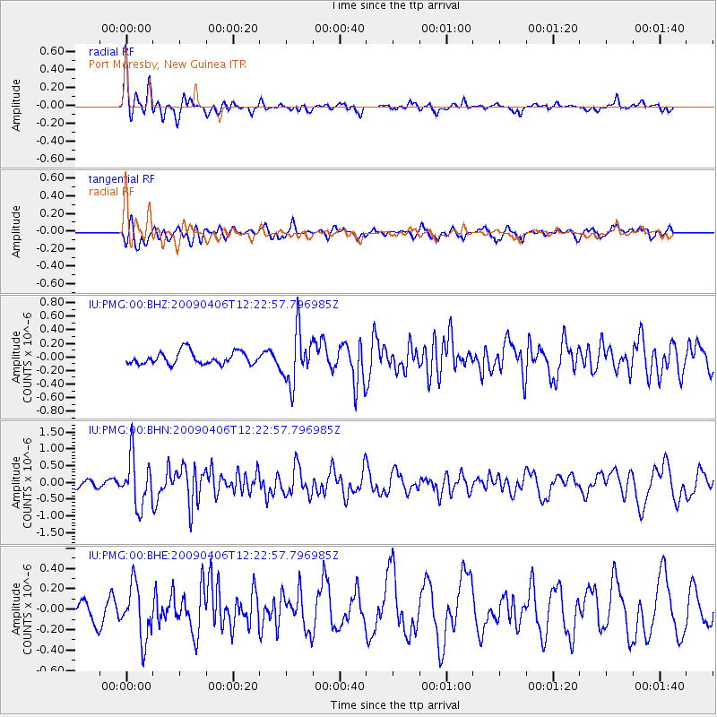
PMG Port Moresby, New Guinea - Earthquake Result Viewer
*The percent match for this event was below the threshold and hence no stack was calculated.
| Earthquake location: |
Tonga Islands Region |
| Earthquake latitude/longitude: |
-22.4/-174.9 |
| Earthquake time(UTC): |
2009/04/06 (096) 12:16:08 GMT |
| Earthquake Depth: |
35 km |
| Earthquake Magnitude: |
5.5 MS, 5.4 MB |
| Earthquake Catalog/Contributor: |
WHDF/NEIC |
|
| Network: |
IU Global Seismograph Network (GSN - IRIS/USGS) |
| Station: |
PMG Port Moresby, New Guinea |
| Lat/Lon: |
9.41 S/147.15 E |
| Elevation: |
67 m |
|
| Distance: |
38.6 deg |
| Az: |
283.402 deg |
| Baz: |
114.152 deg |
| Ray Param: |
$rayparam |
*The percent match for this event was below the threshold and hence was not used in the summary stack. |
|
| Radial Match: |
74.65921 % |
| Radial Bump: |
400 |
| Transverse Match: |
53.67988 % |
| Transverse Bump: |
400 |
| SOD ConfigId: |
2760 |
| Insert Time: |
2010-03-02 15:19:19.986 +0000 |
| GWidth: |
2.5 |
| Max Bumps: |
400 |
| Tol: |
0.001 |
|
Signal To Noise
| Channel | StoN | STA | LTA |
| IU:PMG:00:BHN:20090406T12:22:57.796985Z | 5.676622 | 7.403819E-7 | 1.304265E-7 |
| IU:PMG:00:BHE:20090406T12:22:57.796985Z | 1.5132432 | 2.6808698E-7 | 1.7716054E-7 |
| IU:PMG:00:BHZ:20090406T12:22:57.796985Z | 4.1975636 | 3.8553293E-7 | 9.1846836E-8 |
| Arrivals |
| Ps | |
| PpPs | |
| PsPs/PpSs | |


