You are here: Home > Network List > IU - Global Seismograph Network (GSN - IRIS/USGS) Stations List
> Station PMG Port Moresby, New Guinea > Earthquake Result Viewer
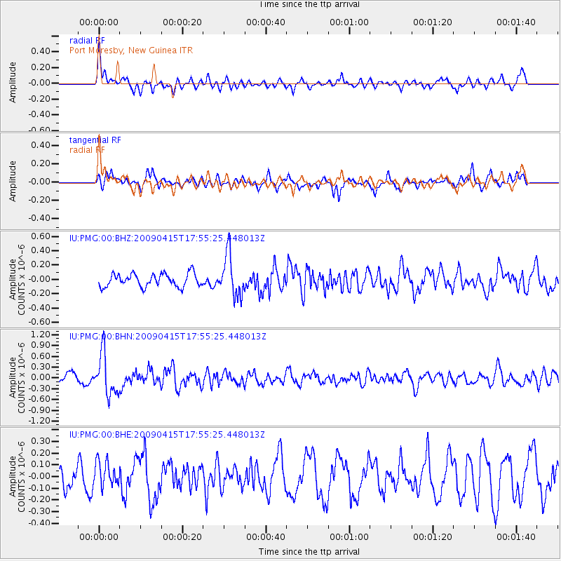
PMG Port Moresby, New Guinea - Earthquake Result Viewer
*The percent match for this event was below the threshold and hence no stack was calculated.
| Earthquake location: |
Southern Sumatra, Indonesia |
| Earthquake latitude/longitude: |
-3.1/100.4 |
| Earthquake time(UTC): |
2009/04/15 (105) 17:47:25 GMT |
| Earthquake Depth: |
6.0 km |
| Earthquake Magnitude: |
5.6 MS, 5.4 MB, 5.8 MW, 5.5 MW |
| Earthquake Catalog/Contributor: |
WHDF/NEIC |
|
| Network: |
IU Global Seismograph Network (GSN - IRIS/USGS) |
| Station: |
PMG Port Moresby, New Guinea |
| Lat/Lon: |
9.41 S/147.15 E |
| Elevation: |
67 m |
|
| Distance: |
46.9 deg |
| Az: |
99.939 deg |
| Baz: |
274.578 deg |
| Ray Param: |
$rayparam |
*The percent match for this event was below the threshold and hence was not used in the summary stack. |
|
| Radial Match: |
70.46315 % |
| Radial Bump: |
399 |
| Transverse Match: |
54.86432 % |
| Transverse Bump: |
366 |
| SOD ConfigId: |
2760 |
| Insert Time: |
2010-03-02 15:19:21.995 +0000 |
| GWidth: |
2.5 |
| Max Bumps: |
400 |
| Tol: |
0.001 |
|
Signal To Noise
| Channel | StoN | STA | LTA |
| IU:PMG:00:BHN:20090415T17:55:25.448013Z | 4.0655727 | 5.8292E-7 | 1.4337955E-7 |
| IU:PMG:00:BHE:20090415T17:55:25.448013Z | 1.2195772 | 1.0837639E-7 | 8.88639E-8 |
| IU:PMG:00:BHZ:20090415T17:55:25.448013Z | 3.2594075 | 2.955245E-7 | 9.066816E-8 |
| Arrivals |
| Ps | |
| PpPs | |
| PsPs/PpSs | |


