You are here: Home > Network List > IU - Global Seismograph Network (GSN - IRIS/USGS) Stations List
> Station PMG Port Moresby, New Guinea > Earthquake Result Viewer
PMG Port Moresby, New Guinea - Earthquake Result Viewer
*The percent match for this event was below the threshold and hence no stack was calculated.
| Earthquake location: |
Kermadec Islands Region |
| Earthquake latitude/longitude: |
-28.9/-177.4 |
| Earthquake time(UTC): |
2009/04/18 (108) 02:03:52 GMT |
| Earthquake Depth: |
65 km |
| Earthquake Magnitude: |
6.0 MB, 5.8 MW, 5.7 MW |
| Earthquake Catalog/Contributor: |
WHDF/NEIC |
|
| Network: |
IU Global Seismograph Network (GSN - IRIS/USGS) |
| Station: |
PMG Port Moresby, New Guinea |
| Lat/Lon: |
9.41 S/147.15 E |
| Elevation: |
67 m |
|
| Distance: |
38.4 deg |
| Az: |
293.158 deg |
| Baz: |
125.223 deg |
| Ray Param: |
$rayparam |
*The percent match for this event was below the threshold and hence was not used in the summary stack. |
|
| Radial Match: |
67.46485 % |
| Radial Bump: |
400 |
| Transverse Match: |
56.491013 % |
| Transverse Bump: |
400 |
| SOD ConfigId: |
2760 |
| Insert Time: |
2010-03-02 15:19:25.137 +0000 |
| GWidth: |
2.5 |
| Max Bumps: |
400 |
| Tol: |
0.001 |
|
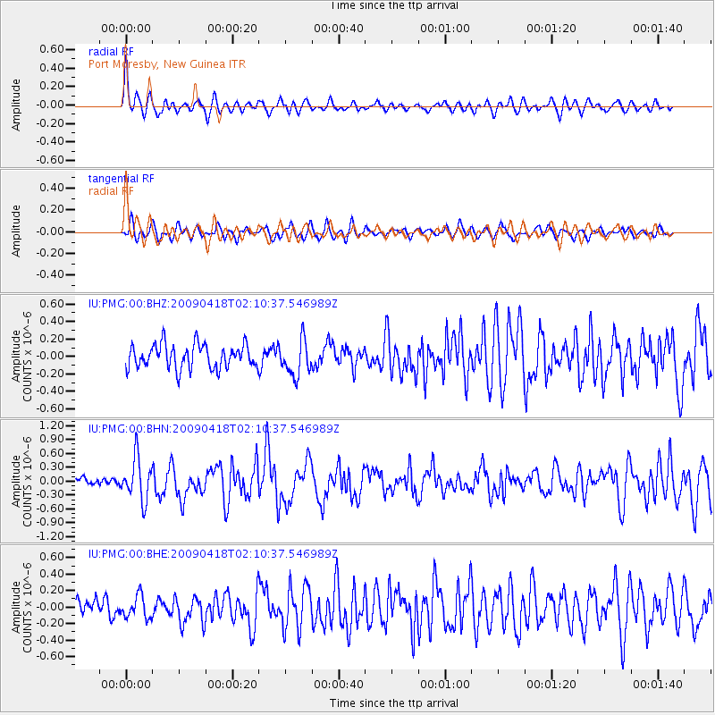
Signal To Noise
| Channel | StoN | STA | LTA |
| IU:PMG:00:BHN:20090418T02:10:37.546989Z | 3.1520498 | 4.5602985E-7 | 1.4467723E-7 |
| IU:PMG:00:BHE:20090418T02:10:37.546989Z | 1.3022311 | 1.373059E-7 | 1.0543898E-7 |
| IU:PMG:00:BHZ:20090418T02:10:37.546989Z | 1.4829975 | 2.01266E-7 | 1.3571567E-7 |
| Arrivals |
| Ps | |
| PpPs | |
| PsPs/PpSs | |


