You are here: Home > Network List > IU - Global Seismograph Network (GSN - IRIS/USGS) Stations List
> Station PMG Port Moresby, New Guinea > Earthquake Result Viewer
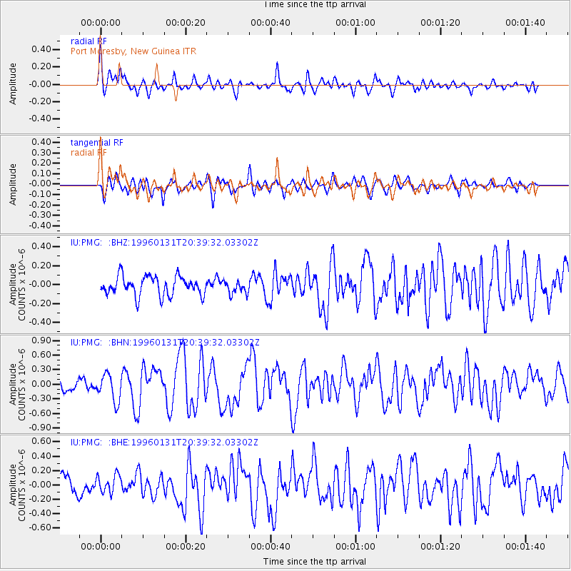
PMG Port Moresby, New Guinea - Earthquake Result Viewer
*The percent match for this event was below the threshold and hence no stack was calculated.
| Earthquake location: |
Kuril Islands |
| Earthquake latitude/longitude: |
44.5/149.4 |
| Earthquake time(UTC): |
1996/01/31 (031) 20:30:47 GMT |
| Earthquake Depth: |
58 km |
| Earthquake Magnitude: |
5.8 MB, 6.1 UNKNOWN, 5.9 MW |
| Earthquake Catalog/Contributor: |
WHDF/NEIC |
|
| Network: |
IU Global Seismograph Network (GSN - IRIS/USGS) |
| Station: |
PMG Port Moresby, New Guinea |
| Lat/Lon: |
9.41 S/147.15 E |
| Elevation: |
67 m |
|
| Distance: |
53.6 deg |
| Az: |
182.718 deg |
| Baz: |
1.972 deg |
| Ray Param: |
$rayparam |
*The percent match for this event was below the threshold and hence was not used in the summary stack. |
|
| Radial Match: |
76.471375 % |
| Radial Bump: |
400 |
| Transverse Match: |
70.73358 % |
| Transverse Bump: |
400 |
| SOD ConfigId: |
4480 |
| Insert Time: |
2010-03-02 15:19:45.992 +0000 |
| GWidth: |
2.5 |
| Max Bumps: |
400 |
| Tol: |
0.001 |
|
Signal To Noise
| Channel | StoN | STA | LTA |
| IU:PMG: :BHN:19960131T20:39:32.03302Z | 3.3562956 | 2.8328586E-7 | 8.440433E-8 |
| IU:PMG: :BHE:19960131T20:39:32.03302Z | 1.2292007 | 1.2650538E-7 | 1.02916786E-7 |
| IU:PMG: :BHZ:19960131T20:39:32.03302Z | 0.69502056 | 6.992031E-8 | 1.0060179E-7 |
| Arrivals |
| Ps | |
| PpPs | |
| PsPs/PpSs | |


