You are here: Home > Network List > IU - Global Seismograph Network (GSN - IRIS/USGS) Stations List
> Station PMG Port Moresby, New Guinea > Earthquake Result Viewer
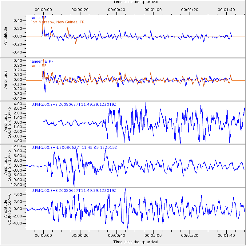
PMG Port Moresby, New Guinea - Earthquake Result Viewer
*The percent match for this event was below the threshold and hence no stack was calculated.
| Earthquake location: |
Andaman Islands, India Region |
| Earthquake latitude/longitude: |
11.0/91.8 |
| Earthquake time(UTC): |
2008/06/27 (179) 11:40:13 GMT |
| Earthquake Depth: |
17 km |
| Earthquake Magnitude: |
6.4 MB, 6.7 MS, 6.6 MW, 6.6 MW |
| Earthquake Catalog/Contributor: |
WHDF/NEIC |
|
| Network: |
IU Global Seismograph Network (GSN - IRIS/USGS) |
| Station: |
PMG Port Moresby, New Guinea |
| Lat/Lon: |
9.41 S/147.15 E |
| Elevation: |
67 m |
|
| Distance: |
58.6 deg |
| Az: |
108.144 deg |
| Baz: |
288.988 deg |
| Ray Param: |
$rayparam |
*The percent match for this event was below the threshold and hence was not used in the summary stack. |
|
| Radial Match: |
79.41612 % |
| Radial Bump: |
400 |
| Transverse Match: |
78.03534 % |
| Transverse Bump: |
400 |
| SOD ConfigId: |
2504 |
| Insert Time: |
2010-03-02 15:19:51.875 +0000 |
| GWidth: |
2.5 |
| Max Bumps: |
400 |
| Tol: |
0.001 |
|
Signal To Noise
| Channel | StoN | STA | LTA |
| IU:PMG:00:BHN:20080627T11:49:39.122019Z | 5.9454136 | 2.1578971E-6 | 3.6295154E-7 |
| IU:PMG:00:BHE:20080627T11:49:39.122019Z | 2.9958801 | 8.291251E-7 | 2.767551E-7 |
| IU:PMG:00:BHZ:20080627T11:49:39.122019Z | 2.0464246 | 7.022512E-7 | 3.4316008E-7 |
| Arrivals |
| Ps | |
| PpPs | |
| PsPs/PpSs | |


