You are here: Home > Network List > IU - Global Seismograph Network (GSN - IRIS/USGS) Stations List
> Station PMG Port Moresby, New Guinea > Earthquake Result Viewer
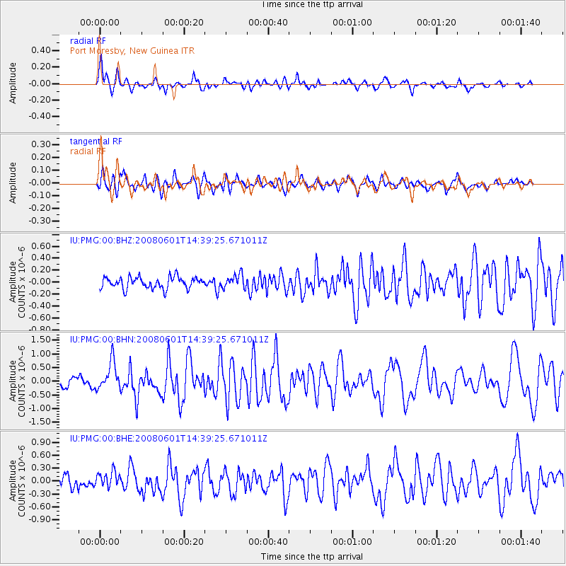
PMG Port Moresby, New Guinea - Earthquake Result Viewer
*The percent match for this event was below the threshold and hence no stack was calculated.
| Earthquake location: |
West Of Macquarie Island |
| Earthquake latitude/longitude: |
-59.4/149.7 |
| Earthquake time(UTC): |
2008/06/01 (153) 14:31:03 GMT |
| Earthquake Depth: |
10 km |
| Earthquake Magnitude: |
5.8 MB, 6.3 MS, 6.5 MW, 6.5 MW |
| Earthquake Catalog/Contributor: |
WHDF/NEIC |
|
| Network: |
IU Global Seismograph Network (GSN - IRIS/USGS) |
| Station: |
PMG Port Moresby, New Guinea |
| Lat/Lon: |
9.41 S/147.15 E |
| Elevation: |
67 m |
|
| Distance: |
49.9 deg |
| Az: |
356.767 deg |
| Baz: |
178.324 deg |
| Ray Param: |
$rayparam |
*The percent match for this event was below the threshold and hence was not used in the summary stack. |
|
| Radial Match: |
75.333595 % |
| Radial Bump: |
400 |
| Transverse Match: |
74.31286 % |
| Transverse Bump: |
400 |
| SOD ConfigId: |
2504 |
| Insert Time: |
2010-03-02 15:20:01.468 +0000 |
| GWidth: |
2.5 |
| Max Bumps: |
400 |
| Tol: |
0.001 |
|
Signal To Noise
| Channel | StoN | STA | LTA |
| IU:PMG:00:BHN:20080601T14:39:25.671011Z | 3.4659562 | 5.329748E-7 | 1.5377425E-7 |
| IU:PMG:00:BHE:20080601T14:39:25.671011Z | 1.1352452 | 1.8451396E-7 | 1.6253226E-7 |
| IU:PMG:00:BHZ:20080601T14:39:25.671011Z | 1.2047544 | 1.1517069E-7 | 9.559683E-8 |
| Arrivals |
| Ps | |
| PpPs | |
| PsPs/PpSs | |


