You are here: Home > Network List > IU - Global Seismograph Network (GSN - IRIS/USGS) Stations List
> Station PMG Port Moresby, New Guinea > Earthquake Result Viewer
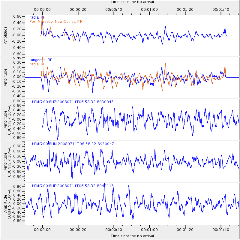
PMG Port Moresby, New Guinea - Earthquake Result Viewer
*The percent match for this event was below the threshold and hence no stack was calculated.
| Earthquake location: |
South Of Java, Indonesia |
| Earthquake latitude/longitude: |
-9.5/107.6 |
| Earthquake time(UTC): |
2008/07/11 (193) 06:51:38 GMT |
| Earthquake Depth: |
16 km |
| Earthquake Magnitude: |
5.5 MB, 4.8 MS, 5.3 MW |
| Earthquake Catalog/Contributor: |
WHDF/NEIC |
|
| Network: |
IU Global Seismograph Network (GSN - IRIS/USGS) |
| Station: |
PMG Port Moresby, New Guinea |
| Lat/Lon: |
9.41 S/147.15 E |
| Elevation: |
67 m |
|
| Distance: |
39.0 deg |
| Az: |
93.208 deg |
| Baz: |
266.489 deg |
| Ray Param: |
$rayparam |
*The percent match for this event was below the threshold and hence was not used in the summary stack. |
|
| Radial Match: |
55.61079 % |
| Radial Bump: |
400 |
| Transverse Match: |
48.93013 % |
| Transverse Bump: |
400 |
| SOD ConfigId: |
2504 |
| Insert Time: |
2010-03-02 15:20:07.347 +0000 |
| GWidth: |
2.5 |
| Max Bumps: |
400 |
| Tol: |
0.001 |
|
Signal To Noise
| Channel | StoN | STA | LTA |
| IU:PMG:00:BHN:20080711T06:58:32.893004Z | 2.500635 | 4.20943E-7 | 1.6833445E-7 |
| IU:PMG:00:BHE:20080711T06:58:32.894011Z | 1.91015 | 3.8130275E-7 | 1.9961925E-7 |
| IU:PMG:00:BHZ:20080711T06:58:32.893004Z | 1.0339348 | 3.0774618E-7 | 2.976456E-7 |
| Arrivals |
| Ps | |
| PpPs | |
| PsPs/PpSs | |


