You are here: Home > Network List > IU - Global Seismograph Network (GSN - IRIS/USGS) Stations List
> Station PMG Port Moresby, New Guinea > Earthquake Result Viewer
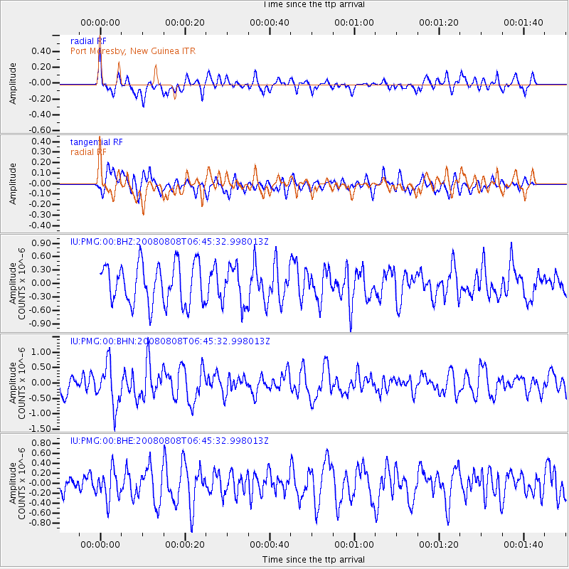
PMG Port Moresby, New Guinea - Earthquake Result Viewer
*The percent match for this event was below the threshold and hence no stack was calculated.
| Earthquake location: |
Southern Sumatra, Indonesia |
| Earthquake latitude/longitude: |
-3.9/101.1 |
| Earthquake time(UTC): |
2008/08/08 (221) 06:37:41 GMT |
| Earthquake Depth: |
23 km |
| Earthquake Magnitude: |
5.5 MB, 5.5 MS, 5.8 MW, 5.8 MW |
| Earthquake Catalog/Contributor: |
WHDF/NEIC |
|
| Network: |
IU Global Seismograph Network (GSN - IRIS/USGS) |
| Station: |
PMG Port Moresby, New Guinea |
| Lat/Lon: |
9.41 S/147.15 E |
| Elevation: |
67 m |
|
| Distance: |
46.1 deg |
| Az: |
99.215 deg |
| Baz: |
273.585 deg |
| Ray Param: |
$rayparam |
*The percent match for this event was below the threshold and hence was not used in the summary stack. |
|
| Radial Match: |
61.774097 % |
| Radial Bump: |
400 |
| Transverse Match: |
59.50591 % |
| Transverse Bump: |
400 |
| SOD ConfigId: |
2504 |
| Insert Time: |
2010-03-02 15:20:15.214 +0000 |
| GWidth: |
2.5 |
| Max Bumps: |
400 |
| Tol: |
0.001 |
|
Signal To Noise
| Channel | StoN | STA | LTA |
| IU:PMG:00:BHN:20080808T06:45:32.998013Z | 2.492855 | 7.068951E-7 | 2.8356848E-7 |
| IU:PMG:00:BHE:20080808T06:45:32.998013Z | 1.3222373 | 2.9154066E-7 | 2.2049042E-7 |
| IU:PMG:00:BHZ:20080808T06:45:32.998013Z | 0.9635268 | 4.3270256E-7 | 4.4908205E-7 |
| Arrivals |
| Ps | |
| PpPs | |
| PsPs/PpSs | |


