You are here: Home > Network List > IU - Global Seismograph Network (GSN - IRIS/USGS) Stations List
> Station PMG Port Moresby, New Guinea > Earthquake Result Viewer
PMG Port Moresby, New Guinea - Earthquake Result Viewer
*The percent match for this event was below the threshold and hence no stack was calculated.
| Earthquake location: |
Tonga Islands |
| Earthquake latitude/longitude: |
-22.0/-173.7 |
| Earthquake time(UTC): |
2008/10/19 (293) 12:55:05 GMT |
| Earthquake Depth: |
35 km |
| Earthquake Magnitude: |
5.7 MB, 5.3 MS, 5.6 MW, 5.5 MW |
| Earthquake Catalog/Contributor: |
WHDF/NEIC |
|
| Network: |
IU Global Seismograph Network (GSN - IRIS/USGS) |
| Station: |
PMG Port Moresby, New Guinea |
| Lat/Lon: |
9.41 S/147.15 E |
| Elevation: |
67 m |
|
| Distance: |
39.6 deg |
| Az: |
282.132 deg |
| Baz: |
113.115 deg |
| Ray Param: |
$rayparam |
*The percent match for this event was below the threshold and hence was not used in the summary stack. |
|
| Radial Match: |
35.845528 % |
| Radial Bump: |
400 |
| Transverse Match: |
45.25463 % |
| Transverse Bump: |
400 |
| SOD ConfigId: |
2556 |
| Insert Time: |
2010-03-02 15:20:23.737 +0000 |
| GWidth: |
2.5 |
| Max Bumps: |
400 |
| Tol: |
0.001 |
|
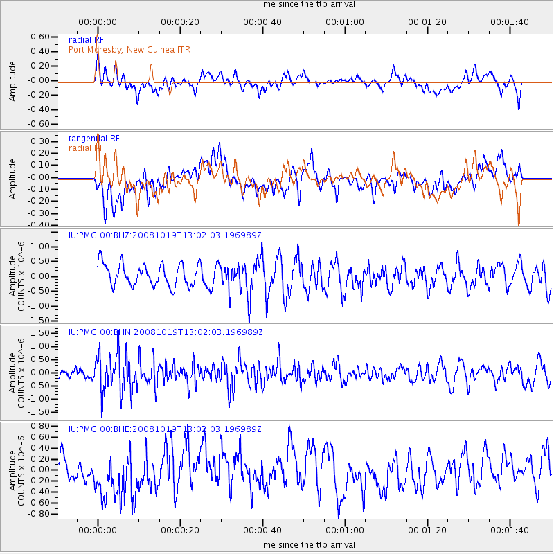
Signal To Noise
| Channel | StoN | STA | LTA |
| IU:PMG:00:BHN:20081019T13:02:03.196989Z | 3.1735394 | 6.962504E-7 | 2.193924E-7 |
| IU:PMG:00:BHE:20081019T13:02:03.196989Z | 1.1968753 | 3.999367E-7 | 3.3415068E-7 |
| IU:PMG:00:BHZ:20081019T13:02:03.196989Z | 1.0418768 | 3.7940717E-7 | 3.6415744E-7 |
| Arrivals |
| Ps | |
| PpPs | |
| PsPs/PpSs | |


