You are here: Home > Network List > IU - Global Seismograph Network (GSN - IRIS/USGS) Stations List
> Station PMG Port Moresby, New Guinea > Earthquake Result Viewer
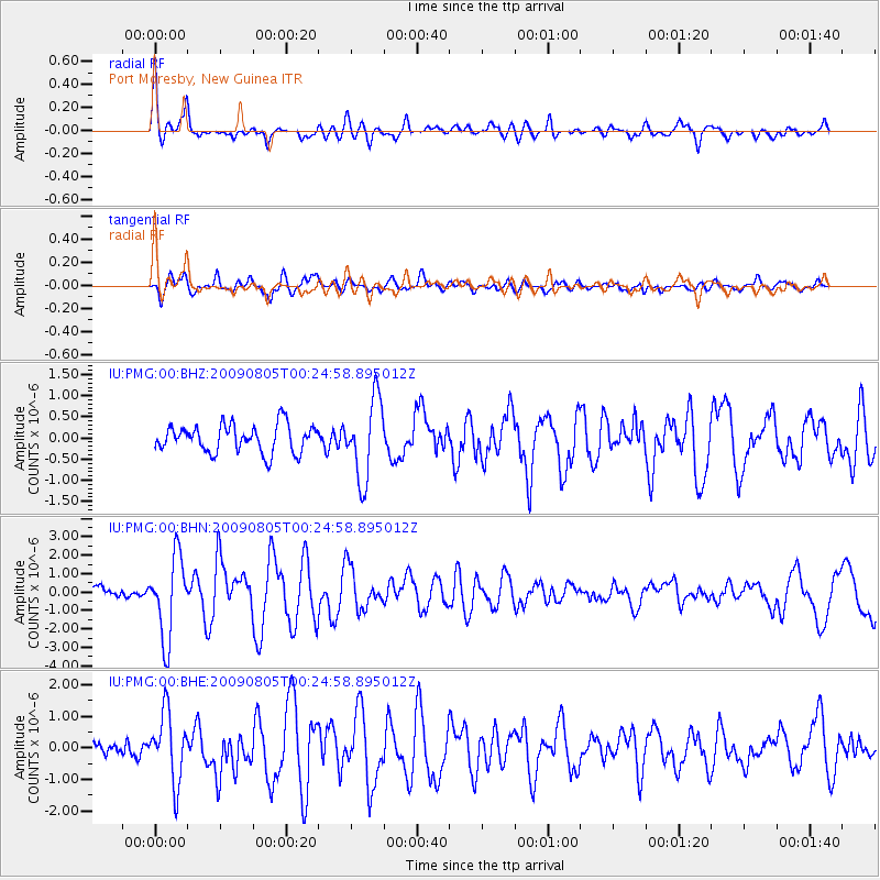
PMG Port Moresby, New Guinea - Earthquake Result Viewer
*The percent match for this event was below the threshold and hence no stack was calculated.
| Earthquake location: |
Southwestern Ryukyu Isl., Japan |
| Earthquake latitude/longitude: |
24.2/125.1 |
| Earthquake time(UTC): |
2009/08/05 (217) 00:17:58 GMT |
| Earthquake Depth: |
25 km |
| Earthquake Magnitude: |
5.9 MB, 5.9 MS, 6.2 MW, 6.1 MW |
| Earthquake Catalog/Contributor: |
WHDF/NEIC |
|
| Network: |
IU Global Seismograph Network (GSN - IRIS/USGS) |
| Station: |
PMG Port Moresby, New Guinea |
| Lat/Lon: |
9.41 S/147.15 E |
| Elevation: |
67 m |
|
| Distance: |
39.8 deg |
| Az: |
144.604 deg |
| Baz: |
327.596 deg |
| Ray Param: |
$rayparam |
*The percent match for this event was below the threshold and hence was not used in the summary stack. |
|
| Radial Match: |
78.96403 % |
| Radial Bump: |
400 |
| Transverse Match: |
67.84954 % |
| Transverse Bump: |
400 |
| SOD ConfigId: |
2622 |
| Insert Time: |
2010-03-02 15:20:32.276 +0000 |
| GWidth: |
2.5 |
| Max Bumps: |
400 |
| Tol: |
0.001 |
|
Signal To Noise
| Channel | StoN | STA | LTA |
| IU:PMG:00:BHN:20090805T00:24:58.895012Z | 7.4860725 | 2.1880992E-6 | 2.9228934E-7 |
| IU:PMG:00:BHE:20090805T00:24:58.895012Z | 5.5474744 | 1.081129E-6 | 1.948867E-7 |
| IU:PMG:00:BHZ:20090805T00:24:58.895012Z | 2.8787084 | 9.3586357E-7 | 3.2509843E-7 |
| Arrivals |
| Ps | |
| PpPs | |
| PsPs/PpSs | |


