You are here: Home > Network List > X812 - Deep Structure of Three Continental Sutures in Eastern North America Stations List
> Station QM31 Togue Pond, Maine, USA > Earthquake Result Viewer
QM31 Togue Pond, Maine, USA - Earthquake Result Viewer
| Earthquake location: |
Near Coast Of Northern Chile |
| Earthquake latitude/longitude: |
-20.2/-70.7 |
| Earthquake time(UTC): |
2015/05/22 (142) 19:39:34 GMT |
| Earthquake Depth: |
20 km |
| Earthquake Magnitude: |
5.3 MW, 5.3 mb, 5.0 MS |
| Earthquake Catalog/Contributor: |
ISC/ISC |
|
| Network: |
X8 Deep Structure of Three Continental Sutures in Eastern North America |
| Station: |
QM31 Togue Pond, Maine, USA |
| Lat/Lon: |
46.93 N/68.89 W |
| Elevation: |
0.0 m |
|
| Distance: |
66.8 deg |
| Az: |
1.357 deg |
| Baz: |
181.861 deg |
| Ray Param: |
0.057360757 |
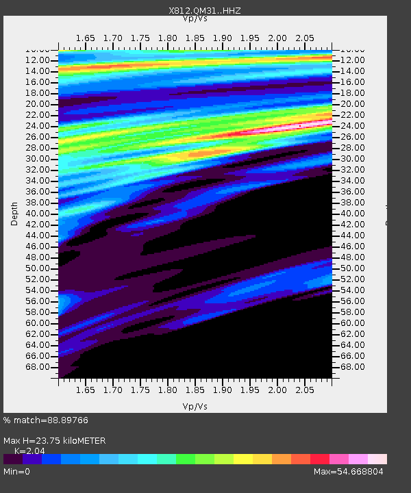
| Estimated Moho Depth: |
23.75 km |
| Estimated Crust Vp/Vs: |
2.04 |
| Assumed Crust Vp: |
6.419 km/s |
| Estimated Crust Vs: |
3.147 km/s |
| Estimated Crust Poisson's Ratio: |
0.34 |
|
| Radial Match: |
88.89766 % |
| Radial Bump: |
400 |
| Transverse Match: |
79.51883 % |
| Transverse Bump: |
400 |
| SOD ConfigId: |
7422571 |
| Insert Time: |
2019-04-19 00:30:42.577 +0000 |
| GWidth: |
2.5 |
| Max Bumps: |
400 |
| Tol: |
0.001 |
|

Signal To Noise
| Channel | StoN | STA | LTA |
| X8:QM31: :HHZ:20150522T19:49:53.350022Z | 1.135 | 2.7086944E-7 | 2.386515E-7 |
| X8:QM31: :HHN:20150522T19:49:53.350022Z | 2.1611967 | 2.6643213E-5 | 1.2327991E-5 |
| X8:QM31: :HHE:20150522T19:49:53.350022Z | 4.741664 | 6.475815E-6 | 1.3657263E-6 |
| Arrivals |
| Ps | 4.0 SECOND |
| PpPs | 11 SECOND |
| PsPs/PpSs | 15 SECOND |


