You are here: Home > Network List > IU - Global Seismograph Network (GSN - IRIS/USGS) Stations List
> Station PMG Port Moresby, New Guinea > Earthquake Result Viewer
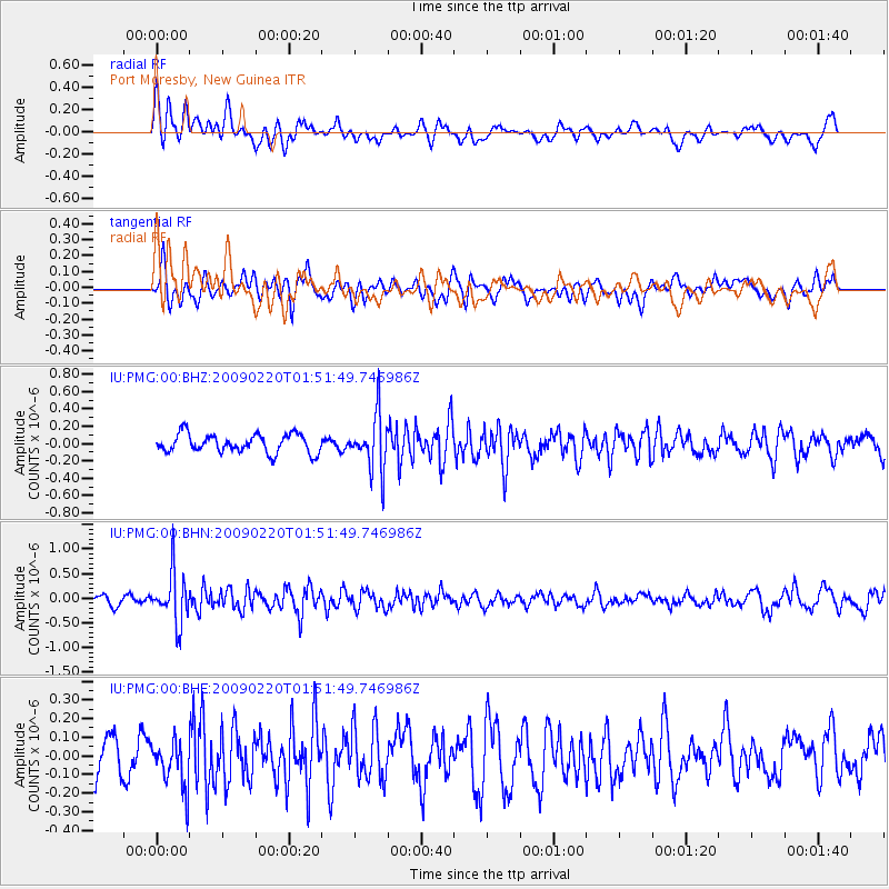
PMG Port Moresby, New Guinea - Earthquake Result Viewer
*The percent match for this event was below the threshold and hence no stack was calculated.
| Earthquake location: |
Fiji Islands Region |
| Earthquake latitude/longitude: |
-18.4/-178.7 |
| Earthquake time(UTC): |
2009/02/20 (051) 01:46:17 GMT |
| Earthquake Depth: |
515 km |
| Earthquake Magnitude: |
5.6 MW, 5.1 MB, 5.6 MW |
| Earthquake Catalog/Contributor: |
WHDF/NEIC |
|
| Network: |
IU Global Seismograph Network (GSN - IRIS/USGS) |
| Station: |
PMG Port Moresby, New Guinea |
| Lat/Lon: |
9.41 S/147.15 E |
| Elevation: |
67 m |
|
| Distance: |
34.2 deg |
| Az: |
280.412 deg |
| Baz: |
108.803 deg |
| Ray Param: |
$rayparam |
*The percent match for this event was below the threshold and hence was not used in the summary stack. |
|
| Radial Match: |
67.474884 % |
| Radial Bump: |
400 |
| Transverse Match: |
73.01544 % |
| Transverse Bump: |
400 |
| SOD ConfigId: |
2658 |
| Insert Time: |
2010-03-02 15:20:46.347 +0000 |
| GWidth: |
2.5 |
| Max Bumps: |
400 |
| Tol: |
0.001 |
|
Signal To Noise
| Channel | StoN | STA | LTA |
| IU:PMG:00:BHN:20090220T01:51:49.746986Z | 4.299501 | 5.0979406E-7 | 1.1857053E-7 |
| IU:PMG:00:BHE:20090220T01:51:49.746986Z | 1.6459466 | 1.265045E-7 | 7.68582E-8 |
| IU:PMG:00:BHZ:20090220T01:51:49.746986Z | 2.9861498 | 3.1546594E-7 | 1.0564304E-7 |
| Arrivals |
| Ps | |
| PpPs | |
| PsPs/PpSs | |


