You are here: Home > Network List > AE - Arizona Broadband Seismic Network Stations List
> Station 113A Mohawk Valley, Roll, AZ, USA > Earthquake Result Viewer
113A Mohawk Valley, Roll, AZ, USA - Earthquake Result Viewer
| Earthquake location: |
Solomon Islands |
| Earthquake latitude/longitude: |
-11.1/163.7 |
| Earthquake time(UTC): |
2015/05/22 (142) 21:45:18 GMT |
| Earthquake Depth: |
7.9 km |
| Earthquake Magnitude: |
6.8 MO |
| Earthquake Catalog/Contributor: |
NEIC PDE/NEIC ALERT |
|
| Network: |
AE Arizona Broadband Seismic Network |
| Station: |
113A Mohawk Valley, Roll, AZ, USA |
| Lat/Lon: |
32.77 N/113.77 W |
| Elevation: |
118 m |
|
| Distance: |
89.8 deg |
| Az: |
56.658 deg |
| Baz: |
256.73 deg |
| Ray Param: |
0.041722663 |
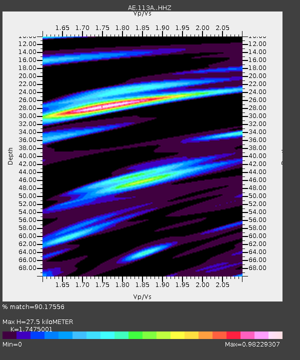
| Estimated Moho Depth: |
27.5 km |
| Estimated Crust Vp/Vs: |
1.75 |
| Assumed Crust Vp: |
6.264 km/s |
| Estimated Crust Vs: |
3.584 km/s |
| Estimated Crust Poisson's Ratio: |
0.26 |
|
| Radial Match: |
90.17556 % |
| Radial Bump: |
400 |
| Transverse Match: |
85.391045 % |
| Transverse Bump: |
400 |
| SOD ConfigId: |
7422571 |
| Insert Time: |
2019-04-19 00:31:47.600 +0000 |
| GWidth: |
2.5 |
| Max Bumps: |
400 |
| Tol: |
0.001 |
|

Signal To Noise
| Channel | StoN | STA | LTA |
| AE:113A: :HHZ:20150522T21:57:46.038989Z | 8.080558 | 5.630672E-7 | 6.968172E-8 |
| AE:113A: :HHN:20150522T21:57:46.038989Z | 1.1286763 | 8.2777916E-8 | 7.334071E-8 |
| AE:113A: :HHE:20150522T21:57:46.038989Z | 3.0068266 | 1.9160068E-7 | 6.372189E-8 |
| Arrivals |
| Ps | 3.3 SECOND |
| PpPs | 12 SECOND |
| PsPs/PpSs | 15 SECOND |


