You are here: Home > Network List > IU - Global Seismograph Network (GSN - IRIS/USGS) Stations List
> Station PMG Port Moresby, New Guinea > Earthquake Result Viewer
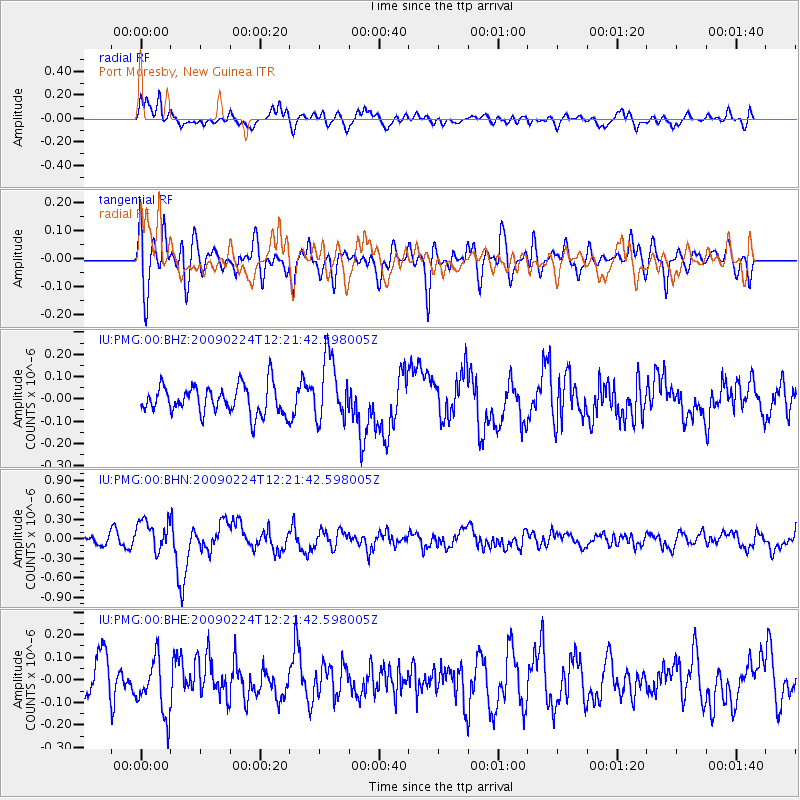
PMG Port Moresby, New Guinea - Earthquake Result Viewer
*The percent match for this event was below the threshold and hence no stack was calculated.
| Earthquake location: |
Northern Sumatra, Indonesia |
| Earthquake latitude/longitude: |
1.4/97.2 |
| Earthquake time(UTC): |
2009/02/24 (055) 12:13:15 GMT |
| Earthquake Depth: |
35 km |
| Earthquake Magnitude: |
5.6 MB, 5.7 MS, 5.7 MW, 5.5 MW |
| Earthquake Catalog/Contributor: |
WHDF/NEIC |
|
| Network: |
IU Global Seismograph Network (GSN - IRIS/USGS) |
| Station: |
PMG Port Moresby, New Guinea |
| Lat/Lon: |
9.41 S/147.15 E |
| Elevation: |
67 m |
|
| Distance: |
50.9 deg |
| Az: |
103.274 deg |
| Baz: |
279.574 deg |
| Ray Param: |
$rayparam |
*The percent match for this event was below the threshold and hence was not used in the summary stack. |
|
| Radial Match: |
67.215744 % |
| Radial Bump: |
400 |
| Transverse Match: |
59.00671 % |
| Transverse Bump: |
400 |
| SOD ConfigId: |
2658 |
| Insert Time: |
2010-03-02 15:21:10.645 +0000 |
| GWidth: |
2.5 |
| Max Bumps: |
400 |
| Tol: |
0.001 |
|
Signal To Noise
| Channel | StoN | STA | LTA |
| IU:PMG:00:BHN:20090224T12:21:42.598005Z | 4.7206516 | 2.430093E-7 | 5.1477915E-8 |
| IU:PMG:00:BHE:20090224T12:21:42.598005Z | 1.1551852 | 1.2276689E-7 | 1.0627463E-7 |
| IU:PMG:00:BHZ:20090224T12:21:42.598005Z | 2.22665 | 1.4360643E-7 | 6.449439E-8 |
| Arrivals |
| Ps | |
| PpPs | |
| PsPs/PpSs | |


