You are here: Home > Network List > AK - Alaska Regional Network Stations List
> Station KNK Knik Glacier, AK, USA > Earthquake Result Viewer
KNK Knik Glacier, AK, USA - Earthquake Result Viewer
| Earthquake location: |
Solomon Islands |
| Earthquake latitude/longitude: |
-11.1/163.7 |
| Earthquake time(UTC): |
2015/05/22 (142) 21:45:18 GMT |
| Earthquake Depth: |
7.9 km |
| Earthquake Magnitude: |
6.8 MO |
| Earthquake Catalog/Contributor: |
NEIC PDE/NEIC ALERT |
|
| Network: |
AK Alaska Regional Network |
| Station: |
KNK Knik Glacier, AK, USA |
| Lat/Lon: |
61.41 N/148.46 W |
| Elevation: |
598 m |
|
| Distance: |
81.4 deg |
| Az: |
21.141 deg |
| Baz: |
227.397 deg |
| Ray Param: |
0.04760679 |
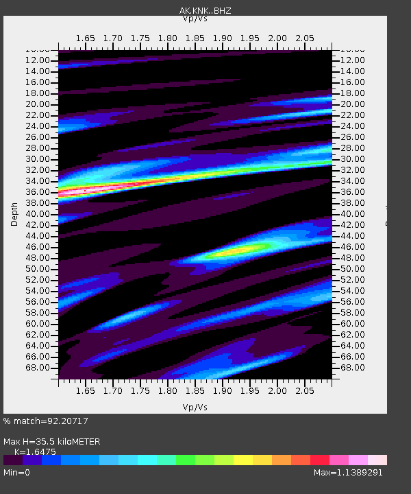
| Estimated Moho Depth: |
35.5 km |
| Estimated Crust Vp/Vs: |
1.65 |
| Assumed Crust Vp: |
6.566 km/s |
| Estimated Crust Vs: |
3.986 km/s |
| Estimated Crust Poisson's Ratio: |
0.21 |
|
| Radial Match: |
92.20717 % |
| Radial Bump: |
400 |
| Transverse Match: |
81.98713 % |
| Transverse Bump: |
400 |
| SOD ConfigId: |
7422571 |
| Insert Time: |
2019-04-19 00:32:17.333 +0000 |
| GWidth: |
2.5 |
| Max Bumps: |
400 |
| Tol: |
0.001 |
|

Signal To Noise
| Channel | StoN | STA | LTA |
| AK:KNK: :BHZ:20150522T21:57:04.687976Z | 5.737434 | 3.6163132E-7 | 6.303015E-8 |
| AK:KNK: :BHN:20150522T21:57:04.687976Z | 1.6629937 | 1.0902492E-7 | 6.555943E-8 |
| AK:KNK: :BHE:20150522T21:57:04.687976Z | 1.8574805 | 1.6482247E-7 | 8.8734424E-8 |
| Arrivals |
| Ps | 3.6 SECOND |
| PpPs | 14 SECOND |
| PsPs/PpSs | 17 SECOND |


