You are here: Home > Network List > IU - Global Seismograph Network (GSN - IRIS/USGS) Stations List
> Station PMG Port Moresby, New Guinea > Earthquake Result Viewer
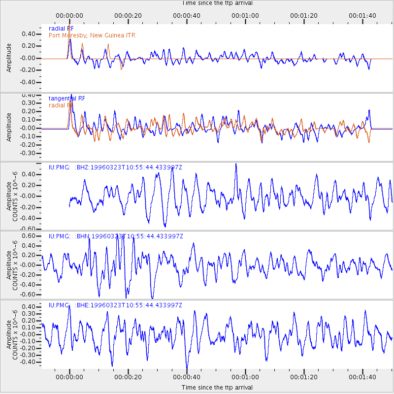
PMG Port Moresby, New Guinea - Earthquake Result Viewer
*The percent match for this event was below the threshold and hence no stack was calculated.
| Earthquake location: |
Balleny Islands Region |
| Earthquake latitude/longitude: |
-62.7/164.9 |
| Earthquake time(UTC): |
1996/03/23 (083) 10:46:45 GMT |
| Earthquake Depth: |
10 km |
| Earthquake Magnitude: |
5.5 MS, 5.0 MB |
| Earthquake Catalog/Contributor: |
WHDF/NEIC |
|
| Network: |
IU Global Seismograph Network (GSN - IRIS/USGS) |
| Station: |
PMG Port Moresby, New Guinea |
| Lat/Lon: |
9.41 S/147.15 E |
| Elevation: |
67 m |
|
| Distance: |
54.7 deg |
| Az: |
338.419 deg |
| Baz: |
170.11 deg |
| Ray Param: |
$rayparam |
*The percent match for this event was below the threshold and hence was not used in the summary stack. |
|
| Radial Match: |
54.026043 % |
| Radial Bump: |
400 |
| Transverse Match: |
41.02572 % |
| Transverse Bump: |
350 |
| SOD ConfigId: |
4480 |
| Insert Time: |
2010-03-02 15:21:29.166 +0000 |
| GWidth: |
2.5 |
| Max Bumps: |
400 |
| Tol: |
0.001 |
|
Signal To Noise
| Channel | StoN | STA | LTA |
| IU:PMG: :BHN:19960323T10:55:44.433997Z | 1.0000783 | 1.078719E-7 | 1.0786346E-7 |
| IU:PMG: :BHE:19960323T10:55:44.433997Z | 1.4591111 | 1.9441465E-7 | 1.3324184E-7 |
| IU:PMG: :BHZ:19960323T10:55:44.433997Z | 2.4433358 | 3.3847758E-7 | 1.3853094E-7 |
| Arrivals |
| Ps | |
| PpPs | |
| PsPs/PpSs | |


