You are here: Home > Network List > IU - Global Seismograph Network (GSN - IRIS/USGS) Stations List
> Station PMG Port Moresby, New Guinea > Earthquake Result Viewer
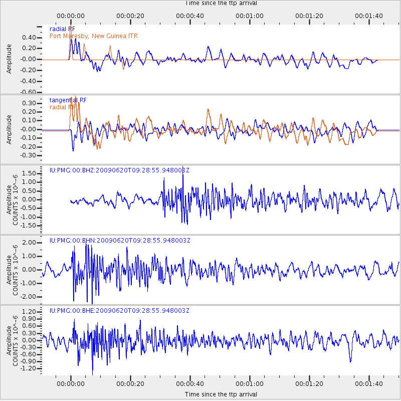
PMG Port Moresby, New Guinea - Earthquake Result Viewer
*The percent match for this event was below the threshold and hence no stack was calculated.
| Earthquake location: |
Southern Sumatra, Indonesia |
| Earthquake latitude/longitude: |
-5.0/103.0 |
| Earthquake time(UTC): |
2009/06/20 (171) 09:21:23 GMT |
| Earthquake Depth: |
46 km |
| Earthquake Magnitude: |
5.8 MB, 5.4 MW, 5.4 MW |
| Earthquake Catalog/Contributor: |
WHDF/NEIC |
|
| Network: |
IU Global Seismograph Network (GSN - IRIS/USGS) |
| Station: |
PMG Port Moresby, New Guinea |
| Lat/Lon: |
9.41 S/147.15 E |
| Elevation: |
67 m |
|
| Distance: |
44.0 deg |
| Az: |
98.333 deg |
| Baz: |
272.555 deg |
| Ray Param: |
$rayparam |
*The percent match for this event was below the threshold and hence was not used in the summary stack. |
|
| Radial Match: |
57.935253 % |
| Radial Bump: |
400 |
| Transverse Match: |
61.052273 % |
| Transverse Bump: |
400 |
| SOD ConfigId: |
2648 |
| Insert Time: |
2010-03-02 15:21:34.664 +0000 |
| GWidth: |
2.5 |
| Max Bumps: |
400 |
| Tol: |
0.001 |
|
Signal To Noise
| Channel | StoN | STA | LTA |
| IU:PMG:00:BHN:20090620T09:28:55.948003Z | 3.056642 | 7.4359787E-7 | 2.432728E-7 |
| IU:PMG:00:BHE:20090620T09:28:55.948003Z | 2.1069272 | 3.9108133E-7 | 1.8561693E-7 |
| IU:PMG:00:BHZ:20090620T09:28:55.948003Z | 2.1341865 | 4.0950403E-7 | 1.9187827E-7 |
| Arrivals |
| Ps | |
| PpPs | |
| PsPs/PpSs | |


