You are here: Home > Network List > IU - Global Seismograph Network (GSN - IRIS/USGS) Stations List
> Station PMG Port Moresby, New Guinea > Earthquake Result Viewer
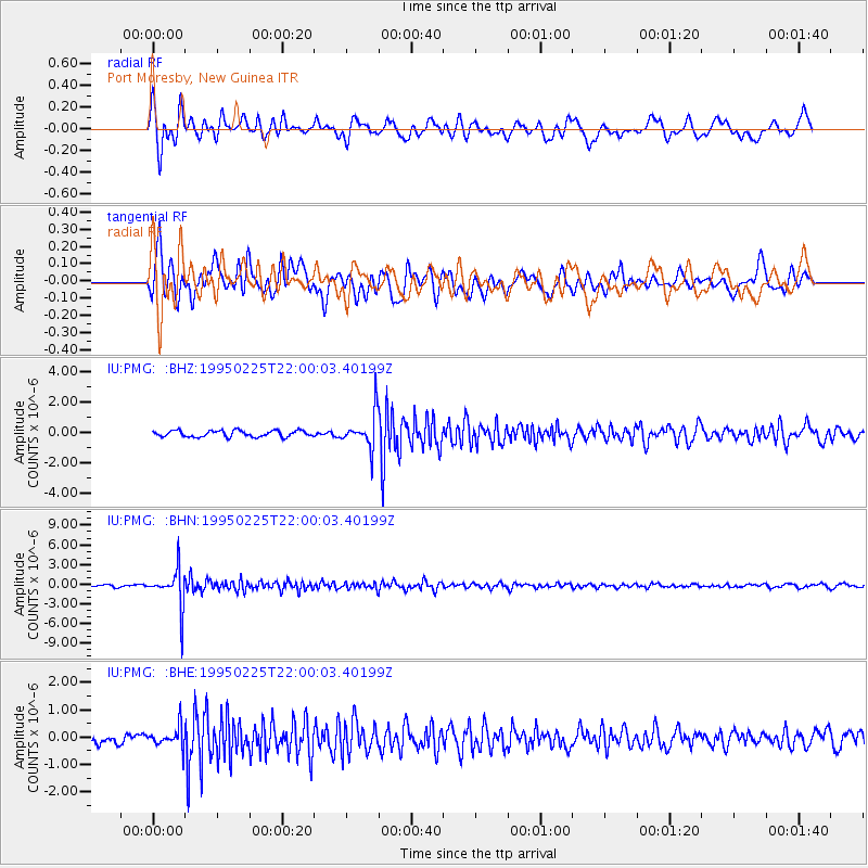
PMG Port Moresby, New Guinea - Earthquake Result Viewer
*The percent match for this event was below the threshold and hence no stack was calculated.
| Earthquake location: |
Fiji Islands Region |
| Earthquake latitude/longitude: |
-18.2/-178.1 |
| Earthquake time(UTC): |
1995/02/25 (056) 21:54:29 GMT |
| Earthquake Depth: |
568 km |
| Earthquake Magnitude: |
5.6 MB, 5.7 UNKNOWN |
| Earthquake Catalog/Contributor: |
WHDF/NEIC |
|
| Network: |
IU Global Seismograph Network (GSN - IRIS/USGS) |
| Station: |
PMG Port Moresby, New Guinea |
| Lat/Lon: |
9.41 S/147.15 E |
| Elevation: |
67 m |
|
| Distance: |
34.8 deg |
| Az: |
279.861 deg |
| Baz: |
108.385 deg |
| Ray Param: |
$rayparam |
*The percent match for this event was below the threshold and hence was not used in the summary stack. |
|
| Radial Match: |
81.086205 % |
| Radial Bump: |
400 |
| Transverse Match: |
75.09586 % |
| Transverse Bump: |
400 |
| SOD ConfigId: |
4480 |
| Insert Time: |
2010-03-02 15:22:02.747 +0000 |
| GWidth: |
2.5 |
| Max Bumps: |
400 |
| Tol: |
0.001 |
|
Signal To Noise
| Channel | StoN | STA | LTA |
| IU:PMG: :BHN:19950225T22:00:03.40199Z | 14.844648 | 2.9807936E-6 | 2.007992E-7 |
| IU:PMG: :BHE:19950225T22:00:03.40199Z | 1.644418 | 3.647016E-7 | 2.2178158E-7 |
| IU:PMG: :BHZ:19950225T22:00:03.40199Z | 5.6585937 | 1.1731644E-6 | 2.0732436E-7 |
| Arrivals |
| Ps | |
| PpPs | |
| PsPs/PpSs | |


