You are here: Home > Network List > IU - Global Seismograph Network (GSN - IRIS/USGS) Stations List
> Station PMG Port Moresby, New Guinea > Earthquake Result Viewer
PMG Port Moresby, New Guinea - Earthquake Result Viewer
*The percent match for this event was below the threshold and hence no stack was calculated.
| Earthquake location: |
Mariana Islands Region |
| Earthquake latitude/longitude: |
21.8/142.6 |
| Earthquake time(UTC): |
1995/04/08 (098) 17:45:18 GMT |
| Earthquake Depth: |
319 km |
| Earthquake Magnitude: |
6.3 MB |
| Earthquake Catalog/Contributor: |
WHDF/NEIC |
|
| Network: |
IU Global Seismograph Network (GSN - IRIS/USGS) |
| Station: |
PMG Port Moresby, New Guinea |
| Lat/Lon: |
9.41 S/147.15 E |
| Elevation: |
67 m |
|
| Distance: |
31.3 deg |
| Az: |
171.397 deg |
| Baz: |
351.901 deg |
| Ray Param: |
$rayparam |
*The percent match for this event was below the threshold and hence was not used in the summary stack. |
|
| Radial Match: |
77.22213 % |
| Radial Bump: |
400 |
| Transverse Match: |
68.85633 % |
| Transverse Bump: |
400 |
| SOD ConfigId: |
4480 |
| Insert Time: |
2010-03-02 15:22:13.031 +0000 |
| GWidth: |
2.5 |
| Max Bumps: |
400 |
| Tol: |
0.001 |
|
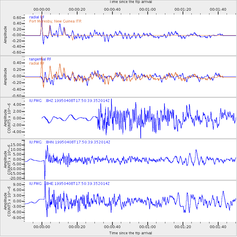
Signal To Noise
| Channel | StoN | STA | LTA |
| IU:PMG: :BHN:19950408T17:50:39.352014Z | 8.634383 | 6.664469E-6 | 7.7185234E-7 |
| IU:PMG: :BHE:19950408T17:50:39.352014Z | 6.6178017 | 4.0277732E-6 | 6.086271E-7 |
| IU:PMG: :BHZ:19950408T17:50:39.352014Z | 3.1757445 | 1.6462562E-6 | 5.1838435E-7 |
| Arrivals |
| Ps | |
| PpPs | |
| PsPs/PpSs | |


