You are here: Home > Network List > TA - USArray Transportable Network (new EarthScope stations) Stations List
> Station J01E Myrtle Point, OR, USA > Earthquake Result Viewer
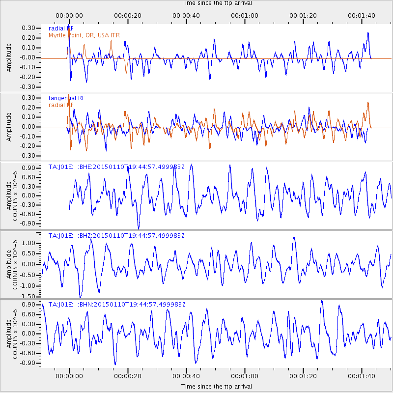
J01E Myrtle Point, OR, USA - Earthquake Result Viewer
*The percent match for this event was below the threshold and hence no stack was calculated.
| Earthquake location: |
Luzon, Philippines |
| Earthquake latitude/longitude: |
14.8/120.3 |
| Earthquake time(UTC): |
2015/01/10 (010) 19:32:02 GMT |
| Earthquake Depth: |
75 km |
| Earthquake Magnitude: |
5.8 MWB |
| Earthquake Catalog/Contributor: |
NEIC PDE/NEIC COMCAT |
|
| Network: |
TA USArray Transportable Network (new EarthScope stations) |
| Station: |
J01E Myrtle Point, OR, USA |
| Lat/Lon: |
43.16 N/123.93 W |
| Elevation: |
128 m |
|
| Distance: |
97.8 deg |
| Az: |
41.678 deg |
| Baz: |
298.466 deg |
| Ray Param: |
$rayparam |
*The percent match for this event was below the threshold and hence was not used in the summary stack. |
|
| Radial Match: |
57.0065 % |
| Radial Bump: |
400 |
| Transverse Match: |
49.19015 % |
| Transverse Bump: |
400 |
| SOD ConfigId: |
828811 |
| Insert Time: |
2015-01-24 19:58:16.298 +0000 |
| GWidth: |
2.5 |
| Max Bumps: |
400 |
| Tol: |
0.001 |
|
Signal To Noise
| Channel | StoN | STA | LTA |
| TA:J01E: :BHZ:20150110T19:44:57.499983Z | 1.7991935 | 7.6310886E-7 | 4.2413942E-7 |
| TA:J01E: :BHN:20150110T19:44:57.499983Z | 0.6801611 | 3.3876535E-7 | 4.980663E-7 |
| TA:J01E: :BHE:20150110T19:44:57.499983Z | 1.0242584 | 3.8261282E-7 | 3.735511E-7 |
| Arrivals |
| Ps | |
| PpPs | |
| PsPs/PpSs | |


