You are here: Home > Network List > IU - Global Seismograph Network (GSN - IRIS/USGS) Stations List
> Station PMG Port Moresby, New Guinea > Earthquake Result Viewer
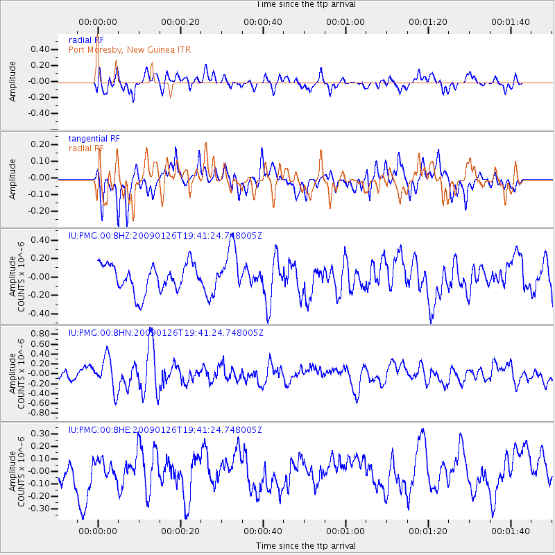
PMG Port Moresby, New Guinea - Earthquake Result Viewer
*The percent match for this event was below the threshold and hence no stack was calculated.
| Earthquake location: |
Southern Sumatra, Indonesia |
| Earthquake latitude/longitude: |
-0.4/98.2 |
| Earthquake time(UTC): |
2009/01/26 (026) 19:33:04 GMT |
| Earthquake Depth: |
10 km |
| Earthquake Magnitude: |
5.6 MW, 5.4 MB |
| Earthquake Catalog/Contributor: |
WHDF/NEIC |
|
| Network: |
IU Global Seismograph Network (GSN - IRIS/USGS) |
| Station: |
PMG Port Moresby, New Guinea |
| Lat/Lon: |
9.41 S/147.15 E |
| Elevation: |
67 m |
|
| Distance: |
49.6 deg |
| Az: |
102.018 deg |
| Baz: |
277.596 deg |
| Ray Param: |
$rayparam |
*The percent match for this event was below the threshold and hence was not used in the summary stack. |
|
| Radial Match: |
52.394398 % |
| Radial Bump: |
400 |
| Transverse Match: |
60.81413 % |
| Transverse Bump: |
400 |
| SOD ConfigId: |
2658 |
| Insert Time: |
2010-03-02 15:22:23.662 +0000 |
| GWidth: |
2.5 |
| Max Bumps: |
400 |
| Tol: |
0.001 |
|
Signal To Noise
| Channel | StoN | STA | LTA |
| IU:PMG:00:BHN:20090126T19:41:24.748005Z | 3.0123599 | 3.4701185E-7 | 1.1519601E-7 |
| IU:PMG:00:BHE:20090126T19:41:24.748005Z | 0.5642562 | 6.682223E-8 | 1.18425326E-7 |
| IU:PMG:00:BHZ:20090126T19:41:24.748005Z | 1.6910635 | 2.491925E-7 | 1.4735846E-7 |
| Arrivals |
| Ps | |
| PpPs | |
| PsPs/PpSs | |


