You are here: Home > Network List > IU - Global Seismograph Network (GSN - IRIS/USGS) Stations List
> Station PMG Port Moresby, New Guinea > Earthquake Result Viewer
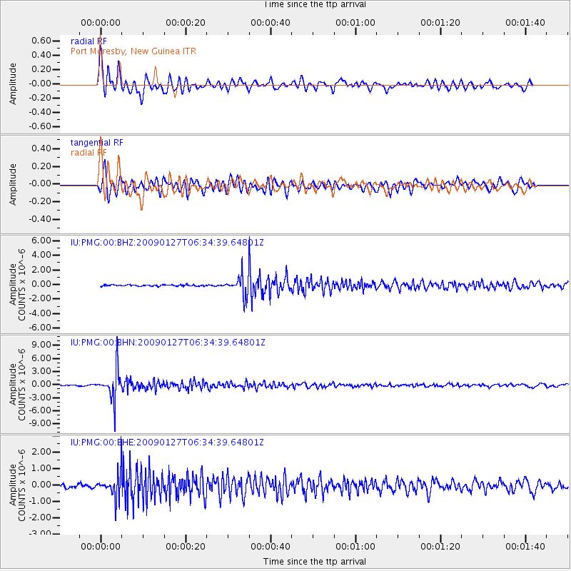
PMG Port Moresby, New Guinea - Earthquake Result Viewer
*The percent match for this event was below the threshold and hence no stack was calculated.
| Earthquake location: |
Fiji Islands Region |
| Earthquake latitude/longitude: |
-17.8/-178.7 |
| Earthquake time(UTC): |
2009/01/27 (027) 06:29:13 GMT |
| Earthquake Depth: |
601 km |
| Earthquake Magnitude: |
5.9 MW, 5.1 MB, 5.8 MW |
| Earthquake Catalog/Contributor: |
WHDF/NEIC |
|
| Network: |
IU Global Seismograph Network (GSN - IRIS/USGS) |
| Station: |
PMG Port Moresby, New Guinea |
| Lat/Lon: |
9.41 S/147.15 E |
| Elevation: |
67 m |
|
| Distance: |
34.2 deg |
| Az: |
279.611 deg |
| Baz: |
107.862 deg |
| Ray Param: |
$rayparam |
*The percent match for this event was below the threshold and hence was not used in the summary stack. |
|
| Radial Match: |
87.75387 % |
| Radial Bump: |
400 |
| Transverse Match: |
87.04499 % |
| Transverse Bump: |
400 |
| SOD ConfigId: |
2658 |
| Insert Time: |
2010-03-02 15:22:26.140 +0000 |
| GWidth: |
2.5 |
| Max Bumps: |
400 |
| Tol: |
0.001 |
|
Signal To Noise
| Channel | StoN | STA | LTA |
| IU:PMG:00:BHN:20090127T06:34:39.64801Z | 40.55846 | 3.4736026E-6 | 8.5644345E-8 |
| IU:PMG:00:BHE:20090127T06:34:39.64801Z | 8.800689 | 7.6318406E-7 | 8.671867E-8 |
| IU:PMG:00:BHZ:20090127T06:34:39.64801Z | 16.15463 | 1.3685744E-6 | 8.471716E-8 |
| Arrivals |
| Ps | |
| PpPs | |
| PsPs/PpSs | |


