You are here: Home > Network List > TA - USArray Transportable Network (new EarthScope stations) Stations List
> Station I23K Minto, Yukon-Koyukuk, AK, USA > Earthquake Result Viewer
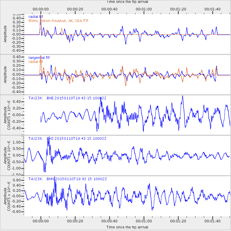
I23K Minto, Yukon-Koyukuk, AK, USA - Earthquake Result Viewer
*The percent match for this event was below the threshold and hence no stack was calculated.
| Earthquake location: |
Luzon, Philippines |
| Earthquake latitude/longitude: |
14.8/120.3 |
| Earthquake time(UTC): |
2015/01/10 (010) 19:32:02 GMT |
| Earthquake Depth: |
75 km |
| Earthquake Magnitude: |
5.8 MWB |
| Earthquake Catalog/Contributor: |
NEIC PDE/NEIC COMCAT |
|
| Network: |
TA USArray Transportable Network (new EarthScope stations) |
| Station: |
I23K Minto, Yukon-Koyukuk, AK, USA |
| Lat/Lon: |
65.15 N/149.36 W |
| Elevation: |
149 m |
|
| Distance: |
76.9 deg |
| Az: |
25.717 deg |
| Baz: |
276.639 deg |
| Ray Param: |
$rayparam |
*The percent match for this event was below the threshold and hence was not used in the summary stack. |
|
| Radial Match: |
62.120697 % |
| Radial Bump: |
400 |
| Transverse Match: |
60.499073 % |
| Transverse Bump: |
396 |
| SOD ConfigId: |
828811 |
| Insert Time: |
2015-01-24 19:58:36.854 +0000 |
| GWidth: |
2.5 |
| Max Bumps: |
400 |
| Tol: |
0.001 |
|
Signal To Noise
| Channel | StoN | STA | LTA |
| TA:I23K: :BHZ:20150110T19:43:15.10002Z | 3.389266 | 6.736112E-7 | 1.987484E-7 |
| TA:I23K: :BHN:20150110T19:43:15.10002Z | 1.0320954 | 1.5988046E-7 | 1.549086E-7 |
| TA:I23K: :BHE:20150110T19:43:15.10002Z | 2.4219983 | 2.1450779E-7 | 8.856645E-8 |
| Arrivals |
| Ps | |
| PpPs | |
| PsPs/PpSs | |


