You are here: Home > Network List > TA - USArray Transportable Network (new EarthScope stations) Stations List
> Station 109C Camp Elliot, Mirimar, CA, USA > Earthquake Result Viewer
109C Camp Elliot, Mirimar, CA, USA - Earthquake Result Viewer

| Earthquake location: |
Solomon Islands |
| Earthquake latitude/longitude: |
-11.1/163.7 |
| Earthquake time(UTC): |
2015/05/22 (142) 21:45:18 GMT |
| Earthquake Depth: |
7.9 km |
| Earthquake Magnitude: |
6.8 MO |
| Earthquake Catalog/Contributor: |
NEIC PDE/NEIC ALERT |
|
| Network: |
TA USArray Transportable Network (new EarthScope stations) |
| Station: |
109C Camp Elliot, Mirimar, CA, USA |
| Lat/Lon: |
32.89 N/117.11 W |
| Elevation: |
150 m |
|
| Distance: |
87.1 deg |
| Az: |
55.853 deg |
| Baz: |
254.906 deg |
| Ray Param: |
0.043603834 |
| Estimated Moho Depth: |
64.0 km |
| Estimated Crust Vp/Vs: |
2.03 |
| Assumed Crust Vp: |
6.264 km/s |
| Estimated Crust Vs: |
3.086 km/s |
| Estimated Crust Poisson's Ratio: |
0.34 |
|
| Radial Match: |
94.08908 % |
| Radial Bump: |
400 |
| Transverse Match: |
82.03642 % |
| Transverse Bump: |
400 |
| SOD ConfigId: |
7422571 |
| Insert Time: |
2019-04-19 00:36:48.403 +0000 |
| GWidth: |
2.5 |
| Max Bumps: |
400 |
| Tol: |
0.001 |
|
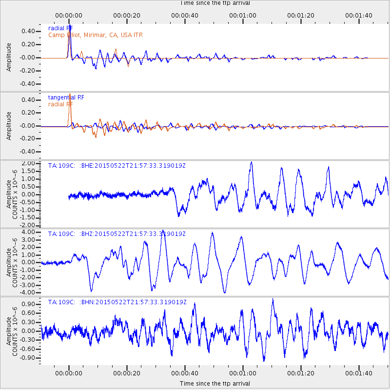
Signal To Noise
| Channel | StoN | STA | LTA |
| TA:109C: :BHZ:20150522T21:57:33.319019Z | 6.2827864 | 6.950464E-7 | 1.106271E-7 |
| TA:109C: :BHN:20150522T21:57:33.319019Z | 1.0977517 | 1.2568329E-7 | 1.1449155E-7 |
| TA:109C: :BHE:20150522T21:57:33.319019Z | 1.7682277 | 1.9074447E-7 | 1.0787325E-7 |
| Arrivals |
| Ps | 11 SECOND |
| PpPs | 30 SECOND |
| PsPs/PpSs | 41 SECOND |


