You are here: Home > Network List > TA - USArray Transportable Network (new EarthScope stations) Stations List
> Station B05D Stanwood, WA, USA > Earthquake Result Viewer
B05D Stanwood, WA, USA - Earthquake Result Viewer
| Earthquake location: |
Solomon Islands |
| Earthquake latitude/longitude: |
-11.1/163.7 |
| Earthquake time(UTC): |
2015/05/22 (142) 21:45:18 GMT |
| Earthquake Depth: |
7.9 km |
| Earthquake Magnitude: |
6.8 MO |
| Earthquake Catalog/Contributor: |
NEIC PDE/NEIC ALERT |
|
| Network: |
TA USArray Transportable Network (new EarthScope stations) |
| Station: |
B05D Stanwood, WA, USA |
| Lat/Lon: |
48.26 N/122.10 W |
| Elevation: |
153 m |
|
| Distance: |
87.9 deg |
| Az: |
40.048 deg |
| Baz: |
250.945 deg |
| Ray Param: |
0.042972498 |
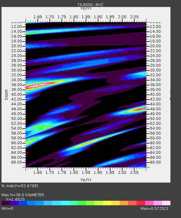
| Estimated Moho Depth: |
36.0 km |
| Estimated Crust Vp/Vs: |
1.65 |
| Assumed Crust Vp: |
6.566 km/s |
| Estimated Crust Vs: |
3.973 km/s |
| Estimated Crust Poisson's Ratio: |
0.21 |
|
| Radial Match: |
92.67091 % |
| Radial Bump: |
377 |
| Transverse Match: |
72.46405 % |
| Transverse Bump: |
400 |
| SOD ConfigId: |
7422571 |
| Insert Time: |
2019-04-19 00:36:51.728 +0000 |
| GWidth: |
2.5 |
| Max Bumps: |
400 |
| Tol: |
0.001 |
|

Signal To Noise
| Channel | StoN | STA | LTA |
| TA:B05D: :BHZ:20150522T21:57:37.450Z | 4.986179 | 5.889117E-7 | 1.18108815E-7 |
| TA:B05D: :BHN:20150522T21:57:37.450Z | 0.54046315 | 7.339389E-8 | 1.3579815E-7 |
| TA:B05D: :BHE:20150522T21:57:37.450Z | 2.0893989 | 1.9674006E-7 | 9.416108E-8 |
| Arrivals |
| Ps | 3.7 SECOND |
| PpPs | 14 SECOND |
| PsPs/PpSs | 18 SECOND |


