You are here: Home > Network List > TA - USArray Transportable Network (new EarthScope stations) Stations List
> Station C06D Leavenworth, WQ, USA > Earthquake Result Viewer
C06D Leavenworth, WQ, USA - Earthquake Result Viewer
| Earthquake location: |
Solomon Islands |
| Earthquake latitude/longitude: |
-11.1/163.7 |
| Earthquake time(UTC): |
2015/05/22 (142) 21:45:18 GMT |
| Earthquake Depth: |
7.9 km |
| Earthquake Magnitude: |
6.8 MO |
| Earthquake Catalog/Contributor: |
NEIC PDE/NEIC ALERT |
|
| Network: |
TA USArray Transportable Network (new EarthScope stations) |
| Station: |
C06D Leavenworth, WQ, USA |
| Lat/Lon: |
47.92 N/120.89 W |
| Elevation: |
544 m |
|
| Distance: |
88.6 deg |
| Az: |
40.628 deg |
| Baz: |
251.854 deg |
| Ray Param: |
0.042485803 |
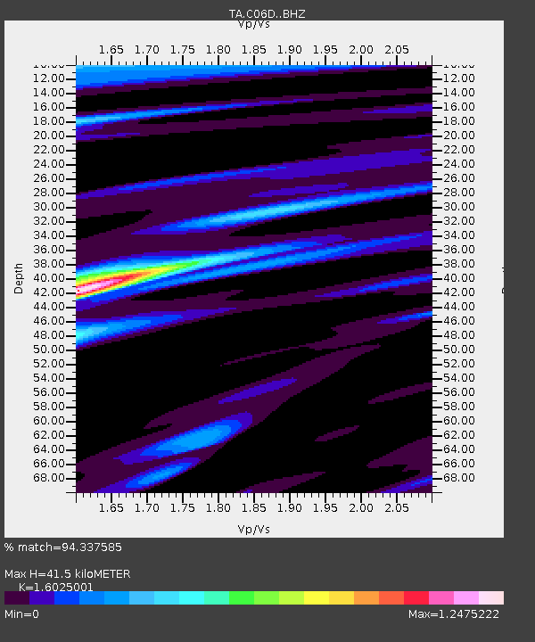
| Estimated Moho Depth: |
41.5 km |
| Estimated Crust Vp/Vs: |
1.60 |
| Assumed Crust Vp: |
6.597 km/s |
| Estimated Crust Vs: |
4.117 km/s |
| Estimated Crust Poisson's Ratio: |
0.18 |
|
| Radial Match: |
94.337585 % |
| Radial Bump: |
400 |
| Transverse Match: |
68.891556 % |
| Transverse Bump: |
400 |
| SOD ConfigId: |
7422571 |
| Insert Time: |
2019-04-19 00:36:53.020 +0000 |
| GWidth: |
2.5 |
| Max Bumps: |
400 |
| Tol: |
0.001 |
|
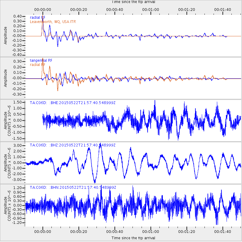
Signal To Noise
| Channel | StoN | STA | LTA |
| TA:C06D: :BHZ:20150522T21:57:40.548999Z | 3.9669142 | 5.2604764E-7 | 1.3260878E-7 |
| TA:C06D: :BHN:20150522T21:57:40.548999Z | 1.0883396 | 3.0639117E-7 | 2.815217E-7 |
| TA:C06D: :BHE:20150522T21:57:40.548999Z | 1.1298898 | 3.0709725E-7 | 2.7179397E-7 |
| Arrivals |
| Ps | 3.9 SECOND |
| PpPs | 16 SECOND |
| PsPs/PpSs | 20 SECOND |


