You are here: Home > Network List > TA - USArray Transportable Network (new EarthScope stations) Stations List
> Station D03D Eldon, WA, USA > Earthquake Result Viewer
D03D Eldon, WA, USA - Earthquake Result Viewer
| Earthquake location: |
Solomon Islands |
| Earthquake latitude/longitude: |
-11.1/163.7 |
| Earthquake time(UTC): |
2015/05/22 (142) 21:45:18 GMT |
| Earthquake Depth: |
7.9 km |
| Earthquake Magnitude: |
6.8 MO |
| Earthquake Catalog/Contributor: |
NEIC PDE/NEIC ALERT |
|
| Network: |
TA USArray Transportable Network (new EarthScope stations) |
| Station: |
D03D Eldon, WA, USA |
| Lat/Lon: |
47.53 N/123.09 W |
| Elevation: |
262 m |
|
| Distance: |
87.1 deg |
| Az: |
40.514 deg |
| Baz: |
250.231 deg |
| Ray Param: |
0.04360776 |
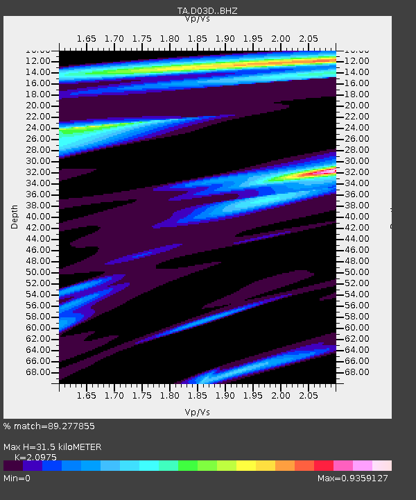
| Estimated Moho Depth: |
31.5 km |
| Estimated Crust Vp/Vs: |
2.10 |
| Assumed Crust Vp: |
6.566 km/s |
| Estimated Crust Vs: |
3.13 km/s |
| Estimated Crust Poisson's Ratio: |
0.35 |
|
| Radial Match: |
89.277855 % |
| Radial Bump: |
400 |
| Transverse Match: |
94.12481 % |
| Transverse Bump: |
259 |
| SOD ConfigId: |
7422571 |
| Insert Time: |
2019-04-19 00:36:53.227 +0000 |
| GWidth: |
2.5 |
| Max Bumps: |
400 |
| Tol: |
0.001 |
|

Signal To Noise
| Channel | StoN | STA | LTA |
| TA:D03D: :BHZ:20150522T21:57:33.249988Z | 3.2858467 | 4.90389E-7 | 1.4924281E-7 |
| TA:D03D: :BHN:20150522T21:57:33.249988Z | 1.1112077 | 1.8730121E-7 | 1.6855644E-7 |
| TA:D03D: :BHE:20150522T21:57:33.249988Z | 3.297006 | 2.5958403E-7 | 7.873326E-8 |
| Arrivals |
| Ps | 5.4 SECOND |
| PpPs | 15 SECOND |
| PsPs/PpSs | 20 SECOND |


