You are here: Home > Network List > IU - Global Seismograph Network (GSN - IRIS/USGS) Stations List
> Station PMG Port Moresby, New Guinea > Earthquake Result Viewer
PMG Port Moresby, New Guinea - Earthquake Result Viewer
*The percent match for this event was below the threshold and hence no stack was calculated.
| Earthquake location: |
Pacific-Antarctic Ridge |
| Earthquake latitude/longitude: |
-56.8/-141.7 |
| Earthquake time(UTC): |
1995/08/23 (235) 13:14:42 GMT |
| Earthquake Depth: |
10 km |
| Earthquake Magnitude: |
5.9 MB, 5.6 MS, 5.5 UNKNOWN, 6.2 MW |
| Earthquake Catalog/Contributor: |
WHDF/NEIC |
|
| Network: |
IU Global Seismograph Network (GSN - IRIS/USGS) |
| Station: |
PMG Port Moresby, New Guinea |
| Lat/Lon: |
9.41 S/147.15 E |
| Elevation: |
67 m |
|
| Distance: |
71.9 deg |
| Az: |
280.691 deg |
| Baz: |
146.731 deg |
| Ray Param: |
$rayparam |
*The percent match for this event was below the threshold and hence was not used in the summary stack. |
|
| Radial Match: |
76.09208 % |
| Radial Bump: |
400 |
| Transverse Match: |
79.84302 % |
| Transverse Bump: |
400 |
| SOD ConfigId: |
4480 |
| Insert Time: |
2010-03-02 15:22:46.879 +0000 |
| GWidth: |
2.5 |
| Max Bumps: |
400 |
| Tol: |
0.001 |
|
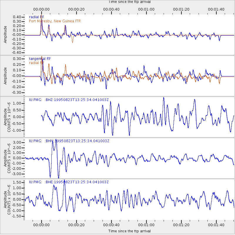
Signal To Noise
| Channel | StoN | STA | LTA |
| IU:PMG: :BHN:19950823T13:25:34.041003Z | 2.8116238 | 6.982339E-7 | 2.483383E-7 |
| IU:PMG: :BHE:19950823T13:25:34.041003Z | 1.3671094 | 3.3930132E-7 | 2.4818885E-7 |
| IU:PMG: :BHZ:19950823T13:25:34.041003Z | 0.9463789 | 2.3969994E-7 | 2.5328117E-7 |
| Arrivals |
| Ps | |
| PpPs | |
| PsPs/PpSs | |


