You are here: Home > Network List > TA - USArray Transportable Network (new EarthScope stations) Stations List
> Station I23K Minto, Yukon-Koyukuk, AK, USA > Earthquake Result Viewer
I23K Minto, Yukon-Koyukuk, AK, USA - Earthquake Result Viewer
| Earthquake location: |
Solomon Islands |
| Earthquake latitude/longitude: |
-11.1/163.7 |
| Earthquake time(UTC): |
2015/05/22 (142) 21:45:18 GMT |
| Earthquake Depth: |
7.9 km |
| Earthquake Magnitude: |
6.8 MO |
| Earthquake Catalog/Contributor: |
NEIC PDE/NEIC ALERT |
|
| Network: |
TA USArray Transportable Network (new EarthScope stations) |
| Station: |
I23K Minto, Yukon-Koyukuk, AK, USA |
| Lat/Lon: |
65.15 N/149.36 W |
| Elevation: |
149 m |
|
| Distance: |
83.7 deg |
| Az: |
18.103 deg |
| Baz: |
226.198 deg |
| Ray Param: |
0.046016056 |
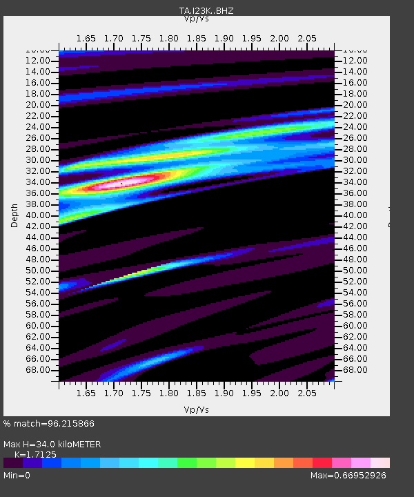
| Estimated Moho Depth: |
34.0 km |
| Estimated Crust Vp/Vs: |
1.71 |
| Assumed Crust Vp: |
6.566 km/s |
| Estimated Crust Vs: |
3.834 km/s |
| Estimated Crust Poisson's Ratio: |
0.24 |
|
| Radial Match: |
96.215866 % |
| Radial Bump: |
183 |
| Transverse Match: |
85.023964 % |
| Transverse Bump: |
360 |
| SOD ConfigId: |
7422571 |
| Insert Time: |
2019-04-19 00:37:02.273 +0000 |
| GWidth: |
2.5 |
| Max Bumps: |
400 |
| Tol: |
0.001 |
|

Signal To Noise
| Channel | StoN | STA | LTA |
| TA:I23K: :BHZ:20150522T21:57:16.450Z | 3.7289243 | 2.538424E-7 | 6.807389E-8 |
| TA:I23K: :BHN:20150522T21:57:16.450Z | 1.6195471 | 1.1666805E-7 | 7.203745E-8 |
| TA:I23K: :BHE:20150522T21:57:16.450Z | 1.2594038 | 1.0943796E-7 | 8.689664E-8 |
| Arrivals |
| Ps | 3.8 SECOND |
| PpPs | 14 SECOND |
| PsPs/PpSs | 17 SECOND |


