You are here: Home > Network List > TA - USArray Transportable Network (new EarthScope stations) Stations List
> Station K27K Chicken, AK, USA > Earthquake Result Viewer
K27K Chicken, AK, USA - Earthquake Result Viewer
| Earthquake location: |
Solomon Islands |
| Earthquake latitude/longitude: |
-11.1/163.7 |
| Earthquake time(UTC): |
2015/05/22 (142) 21:45:18 GMT |
| Earthquake Depth: |
7.9 km |
| Earthquake Magnitude: |
6.8 MO |
| Earthquake Catalog/Contributor: |
NEIC PDE/NEIC ALERT |
|
| Network: |
TA USArray Transportable Network (new EarthScope stations) |
| Station: |
K27K Chicken, AK, USA |
| Lat/Lon: |
64.03 N/142.08 W |
| Elevation: |
389 m |
|
| Distance: |
85.4 deg |
| Az: |
21.006 deg |
| Baz: |
233.049 deg |
| Ray Param: |
0.04482967 |
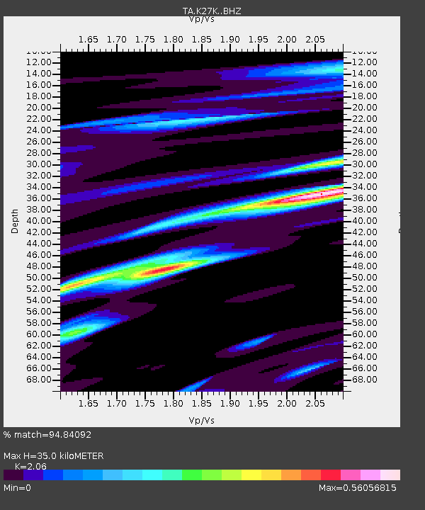
| Estimated Moho Depth: |
35.0 km |
| Estimated Crust Vp/Vs: |
2.06 |
| Assumed Crust Vp: |
6.566 km/s |
| Estimated Crust Vs: |
3.187 km/s |
| Estimated Crust Poisson's Ratio: |
0.35 |
|
| Radial Match: |
94.84092 % |
| Radial Bump: |
343 |
| Transverse Match: |
84.38038 % |
| Transverse Bump: |
400 |
| SOD ConfigId: |
7422571 |
| Insert Time: |
2019-04-19 00:37:07.312 +0000 |
| GWidth: |
2.5 |
| Max Bumps: |
400 |
| Tol: |
0.001 |
|

Signal To Noise
| Channel | StoN | STA | LTA |
| TA:K27K: :BHZ:20150522T21:57:24.850024Z | 4.7567167 | 3.7703768E-7 | 7.926427E-8 |
| TA:K27K: :BHN:20150522T21:57:24.850024Z | 1.3585049 | 8.1621806E-8 | 6.008209E-8 |
| TA:K27K: :BHE:20150522T21:57:24.850024Z | 3.3277094 | 1.2699584E-7 | 3.8163137E-8 |
| Arrivals |
| Ps | 5.8 SECOND |
| PpPs | 16 SECOND |
| PsPs/PpSs | 22 SECOND |


