You are here: Home > Network List > TA - USArray Transportable Network (new EarthScope stations) Stations List
> Station W18A Petrified Forest, AZ, USA > Earthquake Result Viewer
W18A Petrified Forest, AZ, USA - Earthquake Result Viewer
| Earthquake location: |
Solomon Islands |
| Earthquake latitude/longitude: |
-11.1/163.7 |
| Earthquake time(UTC): |
2015/05/22 (142) 21:45:18 GMT |
| Earthquake Depth: |
7.9 km |
| Earthquake Magnitude: |
6.8 MO |
| Earthquake Catalog/Contributor: |
NEIC PDE/NEIC ALERT |
|
| Network: |
TA USArray Transportable Network (new EarthScope stations) |
| Station: |
W18A Petrified Forest, AZ, USA |
| Lat/Lon: |
35.12 N/109.74 W |
| Elevation: |
1750 m |
|
| Distance: |
93.5 deg |
| Az: |
55.071 deg |
| Baz: |
259.017 deg |
| Ray Param: |
0.04124537 |
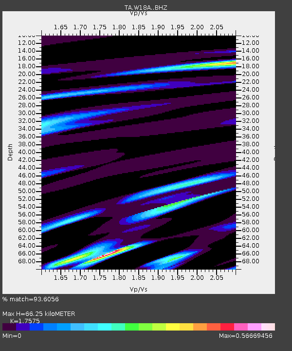
| Estimated Moho Depth: |
66.25 km |
| Estimated Crust Vp/Vs: |
1.76 |
| Assumed Crust Vp: |
6.496 km/s |
| Estimated Crust Vs: |
3.696 km/s |
| Estimated Crust Poisson's Ratio: |
0.26 |
|
| Radial Match: |
93.6056 % |
| Radial Bump: |
400 |
| Transverse Match: |
71.856155 % |
| Transverse Bump: |
400 |
| SOD ConfigId: |
7422571 |
| Insert Time: |
2019-04-19 00:37:19.204 +0000 |
| GWidth: |
2.5 |
| Max Bumps: |
400 |
| Tol: |
0.001 |
|

Signal To Noise
| Channel | StoN | STA | LTA |
| TA:W18A: :BHZ:20150522T21:58:03.424976Z | 5.2249427 | 3.8300837E-7 | 7.3303845E-8 |
| TA:W18A: :BHN:20150522T21:58:03.424976Z | 0.8084041 | 1.1583471E-7 | 1.4328813E-7 |
| TA:W18A: :BHE:20150522T21:58:03.424976Z | 1.5091891 | 2.1230383E-7 | 1.406741E-7 |
| Arrivals |
| Ps | 7.9 SECOND |
| PpPs | 28 SECOND |
| PsPs/PpSs | 35 SECOND |


