You are here: Home > Network List > TO - Tectonic Observatory Stations List
> Station CC10 CCSE CC10 > Earthquake Result Viewer
CC10 CCSE CC10 - Earthquake Result Viewer
| Earthquake location: |
Solomon Islands |
| Earthquake latitude/longitude: |
-11.1/163.7 |
| Earthquake time(UTC): |
2015/05/22 (142) 21:45:18 GMT |
| Earthquake Depth: |
7.9 km |
| Earthquake Magnitude: |
6.8 MO |
| Earthquake Catalog/Contributor: |
NEIC PDE/NEIC ALERT |
|
| Network: |
TO Tectonic Observatory |
| Station: |
CC10 CCSE CC10 |
| Lat/Lon: |
36.05 N/120.82 W |
| Elevation: |
225 m |
|
| Distance: |
85.0 deg |
| Az: |
51.961 deg |
| Baz: |
252.54 deg |
| Ray Param: |
0.04509146 |
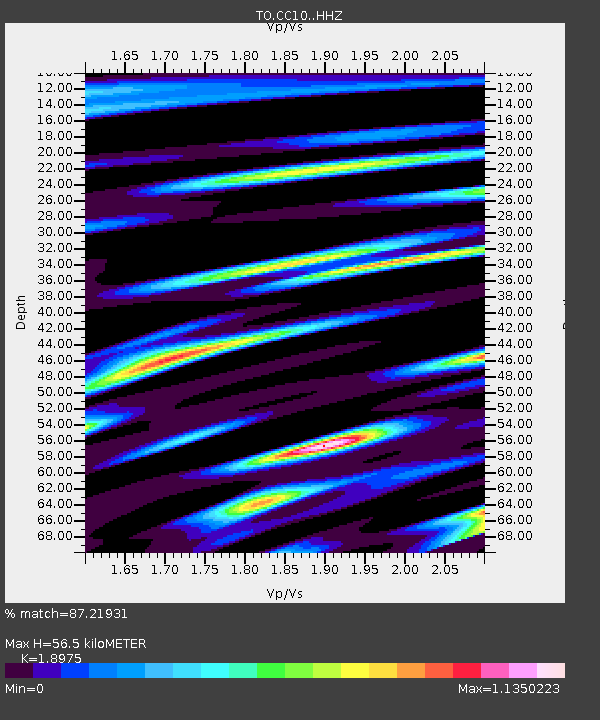
| Estimated Moho Depth: |
56.5 km |
| Estimated Crust Vp/Vs: |
1.90 |
| Assumed Crust Vp: |
6.391 km/s |
| Estimated Crust Vs: |
3.368 km/s |
| Estimated Crust Poisson's Ratio: |
0.31 |
|
| Radial Match: |
87.21931 % |
| Radial Bump: |
400 |
| Transverse Match: |
82.02055 % |
| Transverse Bump: |
400 |
| SOD ConfigId: |
7422571 |
| Insert Time: |
2019-04-19 00:37:35.684 +0000 |
| GWidth: |
2.5 |
| Max Bumps: |
400 |
| Tol: |
0.001 |
|

Signal To Noise
| Channel | StoN | STA | LTA |
| TO:CC10: :HHZ:20150522T21:57:23.140002Z | 7.6694098 | 8.1699153E-7 | 1.06526E-7 |
| TO:CC10: :HHN:20150522T21:57:23.140002Z | 1.467286 | 3.5337868E-7 | 2.4083832E-7 |
| TO:CC10: :HHE:20150522T21:57:23.140002Z | 2.347568 | 3.7052686E-7 | 1.5783435E-7 |
| Arrivals |
| Ps | 8.1 SECOND |
| PpPs | 25 SECOND |
| PsPs/PpSs | 33 SECOND |


