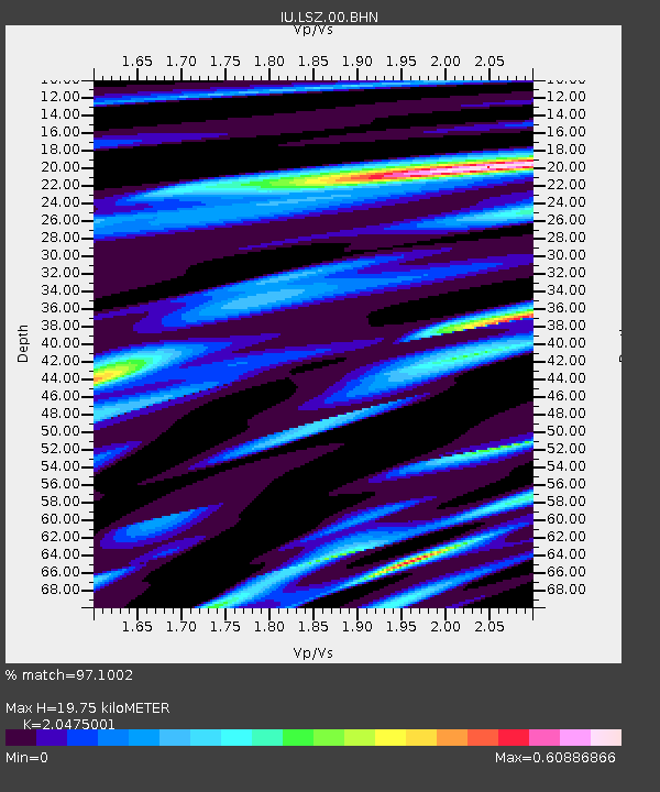
LSZ Lusaka, Zambia - Earthquake Result Viewer
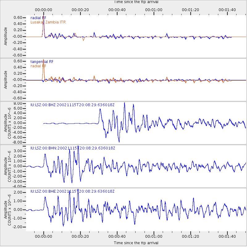
Earthquake location: South Georgia Island Region
Earthquake latitude/longitude: -56.1/-36.4
Earthquake time(UTC): 2002/11/15 (319) 19:58:31 GMT
Earthquake Depth: 10 km
Earthquake Magnitude: 6.1 MB, 6.6 MS, 6.7 MW, 6.4 MW
Earthquake Catalog/Contributor: WHDF/NEIC
Network: IU Global Seismograph Network (GSN - IRIS/USGS)
Station: LSZ Lusaka, Zambia
Lat/Lon: 15.28 S/28.19 E
Elevation: 1184 m
Distance: 63.3 deg
Az: 77.336 deg
Baz: 214.554 deg
Ray Param: 0.059655823
Estimated Moho Depth: 19.75 km
Estimated Crust Vp/Vs: 2.05
Assumed Crust Vp: 6.642 km/s
Estimated Crust Vs: 3.244 km/s
Estimated Crust Poisson's Ratio: 0.34
Radial Match: 97.1002 %
Radial Bump: 274
Transverse Match: 90.65399 %
Transverse Bump: 400
SOD ConfigId: 4714
Insert Time: 2010-03-02 15:23:00.025 +0000
GWidth: 2.5
Max Bumps: 400
Tol: 0.001

Signal To Noise

ChannelStoNSTALTA
IU:LSZ:00:BHN:20021115T20:08:29.636018Z16.1934151.2462715E-67.696162E-8
IU:LSZ:00:BHE:20021115T20:08:29.636018Z11.4444148.0245593E-77.011769E-8
IU:LSZ:00:BHZ:20021115T20:08:29.636018Z29.7298663.2904518E-61.1067832E-7
Arrivals
Ps3.2 SECOND
PpPs8.7 SECOND
PsPs/PpSs12 SECOND