You are here: Home > Network List > XD14 - Illuminating the architecture of the greater Mount St. Helens magmatic systems f Stations List
> Station MD12 "Mount St Helens, WA" > Earthquake Result Viewer
MD12 "Mount St Helens, WA" - Earthquake Result Viewer
| Earthquake location: |
Solomon Islands |
| Earthquake latitude/longitude: |
-11.1/163.7 |
| Earthquake time(UTC): |
2015/05/22 (142) 21:45:18 GMT |
| Earthquake Depth: |
7.9 km |
| Earthquake Magnitude: |
6.8 MO |
| Earthquake Catalog/Contributor: |
NEIC PDE/NEIC ALERT |
|
| Network: |
XD Illuminating the architecture of the greater Mount St. Helens magmatic systems f |
| Station: |
MD12 "Mount St Helens, WA" |
| Lat/Lon: |
46.48 N/121.22 W |
| Elevation: |
1496 m |
|
| Distance: |
87.9 deg |
| Az: |
41.933 deg |
| Baz: |
251.656 deg |
| Ray Param: |
0.0429797 |
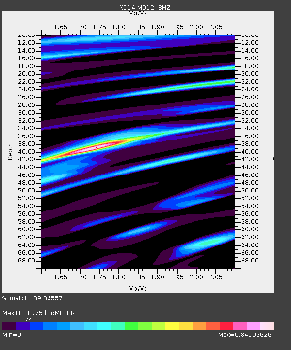
| Estimated Moho Depth: |
38.75 km |
| Estimated Crust Vp/Vs: |
1.74 |
| Assumed Crust Vp: |
6.597 km/s |
| Estimated Crust Vs: |
3.792 km/s |
| Estimated Crust Poisson's Ratio: |
0.25 |
|
| Radial Match: |
89.36557 % |
| Radial Bump: |
400 |
| Transverse Match: |
80.32128 % |
| Transverse Bump: |
400 |
| SOD ConfigId: |
7422571 |
| Insert Time: |
2019-04-19 00:38:32.763 +0000 |
| GWidth: |
2.5 |
| Max Bumps: |
400 |
| Tol: |
0.001 |
|

Signal To Noise
| Channel | StoN | STA | LTA |
| XD:MD12: :BHZ:20150522T21:57:37.405017Z | 5.0480814 | 5.5713207E-7 | 1.1036512E-7 |
| XD:MD12: :BHN:20150522T21:57:37.405017Z | 0.50901765 | 7.900268E-8 | 1.5520618E-7 |
| XD:MD12: :BHE:20150522T21:57:37.405017Z | 1.0127864 | 1.8758382E-7 | 1.8521558E-7 |
| Arrivals |
| Ps | 4.5 SECOND |
| PpPs | 16 SECOND |
| PsPs/PpSs | 20 SECOND |


