You are here: Home > Network List > XD14 - Illuminating the architecture of the greater Mount St. Helens magmatic systems f Stations List
> Station MH03 "Mount St Helens, WA" > Earthquake Result Viewer
MH03 "Mount St Helens, WA" - Earthquake Result Viewer
| Earthquake location: |
Solomon Islands |
| Earthquake latitude/longitude: |
-11.1/163.7 |
| Earthquake time(UTC): |
2015/05/22 (142) 21:45:18 GMT |
| Earthquake Depth: |
7.9 km |
| Earthquake Magnitude: |
6.8 MO |
| Earthquake Catalog/Contributor: |
NEIC PDE/NEIC ALERT |
|
| Network: |
XD Illuminating the architecture of the greater Mount St. Helens magmatic systems f |
| Station: |
MH03 "Mount St Helens, WA" |
| Lat/Lon: |
46.27 N/122.59 W |
| Elevation: |
373 m |
|
| Distance: |
86.9 deg |
| Az: |
41.823 deg |
| Baz: |
250.66 deg |
| Ray Param: |
0.04368398 |
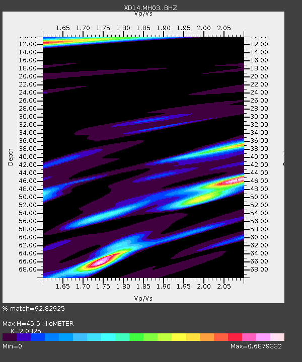
| Estimated Moho Depth: |
45.5 km |
| Estimated Crust Vp/Vs: |
2.08 |
| Assumed Crust Vp: |
6.566 km/s |
| Estimated Crust Vs: |
3.153 km/s |
| Estimated Crust Poisson's Ratio: |
0.35 |
|
| Radial Match: |
92.82925 % |
| Radial Bump: |
324 |
| Transverse Match: |
73.43513 % |
| Transverse Bump: |
400 |
| SOD ConfigId: |
7422571 |
| Insert Time: |
2019-04-19 00:38:43.719 +0000 |
| GWidth: |
2.5 |
| Max Bumps: |
400 |
| Tol: |
0.001 |
|

Signal To Noise
| Channel | StoN | STA | LTA |
| XD:MH03: :BHZ:20150522T21:57:32.765002Z | 3.516687 | 6.260036E-7 | 1.7800949E-7 |
| XD:MH03: :BHN:20150522T21:57:32.765002Z | 0.94006264 | 1.2490523E-7 | 1.3286905E-7 |
| XD:MH03: :BHE:20150522T21:57:32.765002Z | 1.1917843 | 1.8846326E-7 | 1.5813538E-7 |
| Arrivals |
| Ps | 7.7 SECOND |
| PpPs | 21 SECOND |
| PsPs/PpSs | 29 SECOND |


