You are here: Home > Network List > XD14 - Illuminating the architecture of the greater Mount St. Helens magmatic systems f Stations List
> Station MI04 "Mount St Helens, WA" > Earthquake Result Viewer
MI04 "Mount St Helens, WA" - Earthquake Result Viewer
| Earthquake location: |
Solomon Islands |
| Earthquake latitude/longitude: |
-11.1/163.7 |
| Earthquake time(UTC): |
2015/05/22 (142) 21:45:18 GMT |
| Earthquake Depth: |
7.9 km |
| Earthquake Magnitude: |
6.8 MO |
| Earthquake Catalog/Contributor: |
NEIC PDE/NEIC ALERT |
|
| Network: |
XD Illuminating the architecture of the greater Mount St. Helens magmatic systems f |
| Station: |
MI04 "Mount St Helens, WA" |
| Lat/Lon: |
46.20 N/122.41 W |
| Elevation: |
918 m |
|
| Distance: |
87.0 deg |
| Az: |
41.934 deg |
| Baz: |
250.798 deg |
| Ray Param: |
0.04361316 |
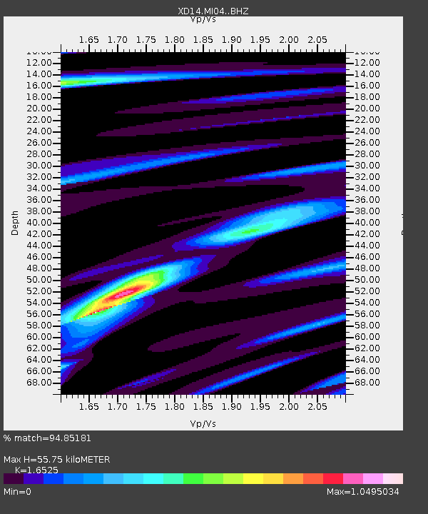
| Estimated Moho Depth: |
55.75 km |
| Estimated Crust Vp/Vs: |
1.65 |
| Assumed Crust Vp: |
6.566 km/s |
| Estimated Crust Vs: |
3.973 km/s |
| Estimated Crust Poisson's Ratio: |
0.21 |
|
| Radial Match: |
94.85181 % |
| Radial Bump: |
400 |
| Transverse Match: |
85.23273 % |
| Transverse Bump: |
400 |
| SOD ConfigId: |
7422571 |
| Insert Time: |
2019-04-19 00:38:48.826 +0000 |
| GWidth: |
2.5 |
| Max Bumps: |
400 |
| Tol: |
0.001 |
|

Signal To Noise
| Channel | StoN | STA | LTA |
| XD:MI04: :BHZ:20150522T21:57:33.225024Z | 4.5096345 | 5.3860947E-7 | 1.1943528E-7 |
| XD:MI04: :BHN:20150522T21:57:33.225024Z | 1.1775556 | 1.898139E-7 | 1.6119316E-7 |
| XD:MI04: :BHE:20150522T21:57:33.225024Z | 2.1170993 | 2.999638E-7 | 1.4168621E-7 |
| Arrivals |
| Ps | 5.7 SECOND |
| PpPs | 22 SECOND |
| PsPs/PpSs | 28 SECOND |


