You are here: Home > Network List > IU - Global Seismograph Network (GSN - IRIS/USGS) Stations List
> Station LSZ Lusaka, Zambia > Earthquake Result Viewer
LSZ Lusaka, Zambia - Earthquake Result Viewer

| Earthquake location: |
Southern Bolivia |
| Earthquake latitude/longitude: |
-21.1/-65.6 |
| Earthquake time(UTC): |
2004/03/17 (077) 03:21:07 GMT |
| Earthquake Depth: |
290 km |
| Earthquake Magnitude: |
5.5 MB, 6.1 MW, 6.1 MW |
| Earthquake Catalog/Contributor: |
WHDF/NEIC |
|
| Network: |
IU Global Seismograph Network (GSN - IRIS/USGS) |
| Station: |
LSZ Lusaka, Zambia |
| Lat/Lon: |
15.28 S/28.19 E |
| Elevation: |
1184 m |
|
| Distance: |
88.0 deg |
| Az: |
105.508 deg |
| Baz: |
248.777 deg |
| Ray Param: |
0.04218255 |
| Estimated Moho Depth: |
45.0 km |
| Estimated Crust Vp/Vs: |
1.60 |
| Assumed Crust Vp: |
6.642 km/s |
| Estimated Crust Vs: |
4.151 km/s |
| Estimated Crust Poisson's Ratio: |
0.18 |
|
| Radial Match: |
86.390686 % |
| Radial Bump: |
251 |
| Transverse Match: |
71.714966 % |
| Transverse Bump: |
400 |
| SOD ConfigId: |
2459 |
| Insert Time: |
2010-03-02 15:23:19.764 +0000 |
| GWidth: |
2.5 |
| Max Bumps: |
400 |
| Tol: |
0.001 |
|
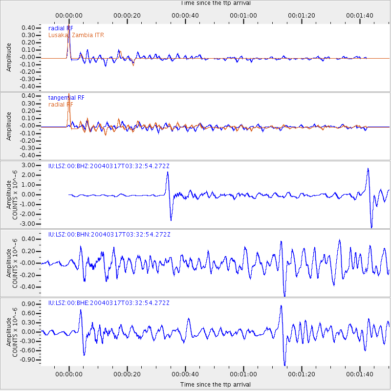
Signal To Noise
| Channel | StoN | STA | LTA |
| IU:LSZ:00:BHN:20040317T03:32:54.272Z | 2.4041805 | 1.0086176E-7 | 4.1952656E-8 |
| IU:LSZ:00:BHE:20040317T03:32:54.272Z | 6.176918 | 2.4922204E-7 | 4.0347313E-8 |
| IU:LSZ:00:BHZ:20040317T03:32:54.272Z | 13.148546 | 8.254608E-7 | 6.277962E-8 |
| Arrivals |
| Ps | 4.2 SECOND |
| PpPs | 17 SECOND |
| PsPs/PpSs | 21 SECOND |


