You are here: Home > Network List > IU - Global Seismograph Network (GSN - IRIS/USGS) Stations List
> Station LSZ Lusaka, Zambia > Earthquake Result Viewer
LSZ Lusaka, Zambia - Earthquake Result Viewer
| Earthquake location: |
South Indian Ocean |
| Earthquake latitude/longitude: |
-36.7/53.4 |
| Earthquake time(UTC): |
2004/01/11 (011) 04:32:47 GMT |
| Earthquake Depth: |
5.3 km |
| Earthquake Magnitude: |
6.1 MB, 6.1 MS, 6.2 MW, 6.2 MW |
| Earthquake Catalog/Contributor: |
WHDF/NEIC |
|
| Network: |
IU Global Seismograph Network (GSN - IRIS/USGS) |
| Station: |
LSZ Lusaka, Zambia |
| Lat/Lon: |
15.28 S/28.19 E |
| Elevation: |
1184 m |
|
| Distance: |
30.9 deg |
| Az: |
307.004 deg |
| Baz: |
138.313 deg |
| Ray Param: |
0.079210654 |
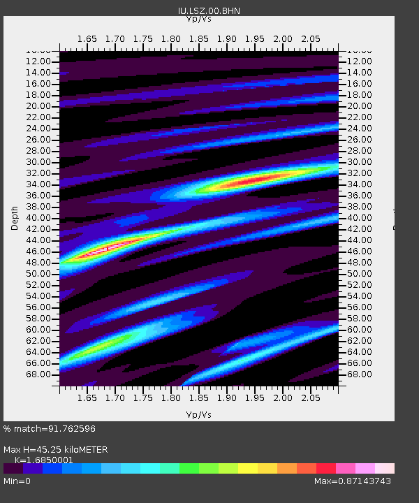
| Estimated Moho Depth: |
45.25 km |
| Estimated Crust Vp/Vs: |
1.69 |
| Assumed Crust Vp: |
6.642 km/s |
| Estimated Crust Vs: |
3.942 km/s |
| Estimated Crust Poisson's Ratio: |
0.23 |
|
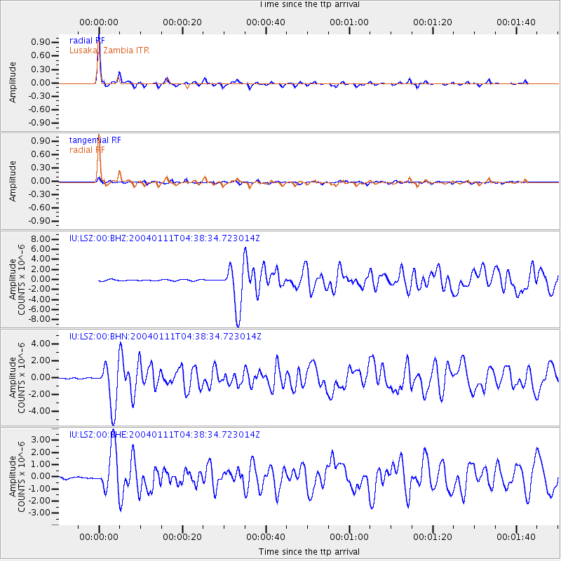
| Radial Match: |
91.762596 % |
| Radial Bump: |
192 |
| Transverse Match: |
75.83315 % |
| Transverse Bump: |
400 |
| SOD ConfigId: |
7314 |
| Insert Time: |
2010-03-02 15:23:25.682 +0000 |
| GWidth: |
2.5 |
| Max Bumps: |
400 |
| Tol: |
0.001 |
|
Signal To Noise
| Channel | StoN | STA | LTA |
| IU:LSZ:00:BHN:20040111T04:38:34.723014Z | 39.813393 | 2.5785416E-6 | 6.4765686E-8 |
| IU:LSZ:00:BHE:20040111T04:38:34.723014Z | 33.84253 | 1.8482028E-6 | 5.4611842E-8 |
| IU:LSZ:00:BHZ:20040111T04:38:34.723014Z | 35.461803 | 4.3777213E-6 | 1.2344891E-7 |
| Arrivals |
| Ps | 5.1 SECOND |
| PpPs | 17 SECOND |
| PsPs/PpSs | 22 SECOND |


