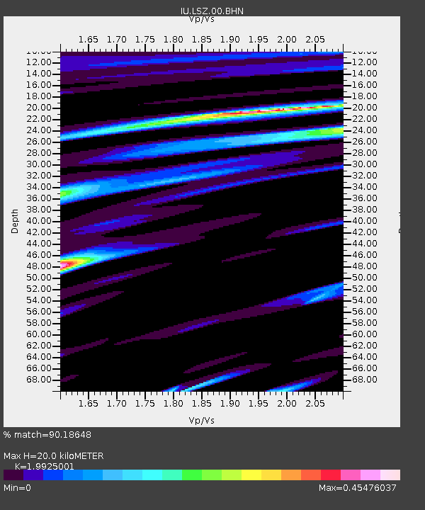
LSZ Lusaka, Zambia - Earthquake Result Viewer

Earthquake location: Southern Sumatra, Indonesia
Earthquake latitude/longitude: -1.6/100.5
Earthquake time(UTC): 2004/02/22 (053) 06:46:27 GMT
Earthquake Depth: 42 km
Earthquake Magnitude: 6.3 MB, 5.7 MS, 6.0 MW, 6.0 MW
Earthquake Catalog/Contributor: WHDF/NEIC
Network: IU Global Seismograph Network (GSN - IRIS/USGS)
Station: LSZ Lusaka, Zambia
Lat/Lon: 15.28 S/28.19 E
Elevation: 1184 m
Distance: 72.5 deg
Az: 254.568 deg
Baz: 86.785 deg
Ray Param: 0.05353484
Estimated Moho Depth: 20.0 km
Estimated Crust Vp/Vs: 1.99
Assumed Crust Vp: 6.642 km/s
Estimated Crust Vs: 3.333 km/s
Estimated Crust Poisson's Ratio: 0.33
Radial Match: 90.18648 %
Radial Bump: 400
Transverse Match: 80.42049 %
Transverse Bump: 400
SOD ConfigId: 2459
Insert Time: 2010-03-02 15:23:30.336 +0000
GWidth: 2.5
Max Bumps: 400
Tol: 0.001

Signal To Noise

ChannelStoNSTALTA
IU:LSZ:00:BHN:20040222T06:57:18.623008Z1.77944741.2542907E-77.048765E-8
IU:LSZ:00:BHE:20040222T06:57:18.623008Z9.6980986.4000227E-76.599256E-8
IU:LSZ:00:BHZ:20040222T06:57:18.623008Z23.5868471.703361E-67.221656E-8
Arrivals
Ps3.1 SECOND
PpPs8.7 SECOND
PsPs/PpSs12 SECOND