You are here: Home > Network List > XD14 - Illuminating the architecture of the greater Mount St. Helens magmatic systems f Stations List
> Station MP10 "Mount St Helens, WA" > Earthquake Result Viewer
MP10 "Mount St Helens, WA" - Earthquake Result Viewer
| Earthquake location: |
Solomon Islands |
| Earthquake latitude/longitude: |
-11.1/163.7 |
| Earthquake time(UTC): |
2015/05/22 (142) 21:45:18 GMT |
| Earthquake Depth: |
7.9 km |
| Earthquake Magnitude: |
6.8 MO |
| Earthquake Catalog/Contributor: |
NEIC PDE/NEIC ALERT |
|
| Network: |
XD Illuminating the architecture of the greater Mount St. Helens magmatic systems f |
| Station: |
MP10 "Mount St Helens, WA" |
| Lat/Lon: |
45.90 N/121.80 W |
| Elevation: |
1130 m |
|
| Distance: |
87.3 deg |
| Az: |
42.354 deg |
| Baz: |
251.256 deg |
| Ray Param: |
0.04338983 |
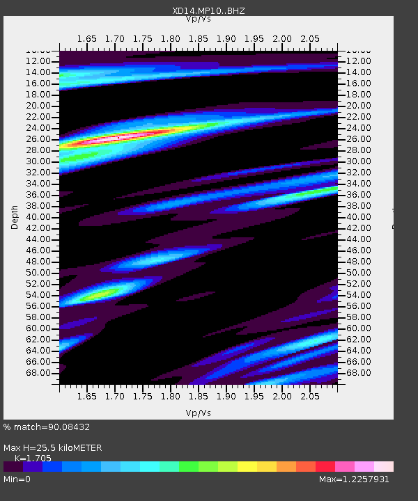
| Estimated Moho Depth: |
25.5 km |
| Estimated Crust Vp/Vs: |
1.71 |
| Assumed Crust Vp: |
6.597 km/s |
| Estimated Crust Vs: |
3.87 km/s |
| Estimated Crust Poisson's Ratio: |
0.24 |
|
| Radial Match: |
90.08432 % |
| Radial Bump: |
400 |
| Transverse Match: |
82.68818 % |
| Transverse Bump: |
400 |
| SOD ConfigId: |
7422571 |
| Insert Time: |
2019-04-19 00:39:14.744 +0000 |
| GWidth: |
2.5 |
| Max Bumps: |
400 |
| Tol: |
0.001 |
|

Signal To Noise
| Channel | StoN | STA | LTA |
| XD:MP10: :BHZ:20150522T21:57:34.694995Z | 6.525485 | 5.9539275E-7 | 9.1241155E-8 |
| XD:MP10: :BHN:20150522T21:57:34.694995Z | 0.767071 | 1.513618E-7 | 1.9732437E-7 |
| XD:MP10: :BHE:20150522T21:57:34.694995Z | 1.7606572 | 2.646148E-7 | 1.502932E-7 |
| Arrivals |
| Ps | 2.8 SECOND |
| PpPs | 10 SECOND |
| PsPs/PpSs | 13 SECOND |


