You are here: Home > Network List > IU - Global Seismograph Network (GSN - IRIS/USGS) Stations List
> Station LSZ Lusaka, Zambia > Earthquake Result Viewer
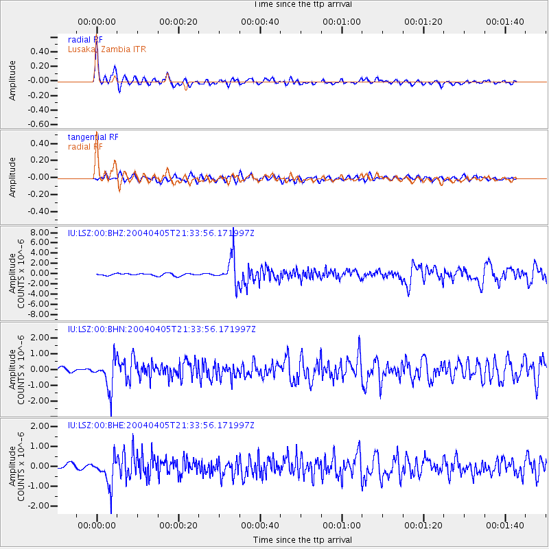
LSZ Lusaka, Zambia - Earthquake Result Viewer

| Earthquake location: |
Afghanistan-Tajikistan Bord Reg. |
| Earthquake latitude/longitude: |
36.5/71.0 |
| Earthquake time(UTC): |
2004/04/05 (096) 21:24:04 GMT |
| Earthquake Depth: |
187 km |
| Earthquake Magnitude: |
6.4 MB, 6.6 MW, 6.5 MW |
| Earthquake Catalog/Contributor: |
WHDF/NEIC |
|
| Network: |
IU Global Seismograph Network (GSN - IRIS/USGS) |
| Station: |
LSZ Lusaka, Zambia |
| Lat/Lon: |
15.28 S/28.19 E |
| Elevation: |
1184 m |
|
| Distance: |
65.5 deg |
| Az: |
226.161 deg |
| Baz: |
37.021 deg |
| Ray Param: |
0.057694204 |
| Estimated Moho Depth: |
25.5 km |
| Estimated Crust Vp/Vs: |
2.09 |
| Assumed Crust Vp: |
6.642 km/s |
| Estimated Crust Vs: |
3.186 km/s |
| Estimated Crust Poisson's Ratio: |
0.35 |
|
| Radial Match: |
89.07637 % |
| Radial Bump: |
400 |
| Transverse Match: |
72.4191 % |
| Transverse Bump: |
400 |
| SOD ConfigId: |
2459 |
| Insert Time: |
2010-03-02 15:23:36.296 +0000 |
| GWidth: |
2.5 |
| Max Bumps: |
400 |
| Tol: |
0.001 |
|
Signal To Noise
| Channel | StoN | STA | LTA |
| IU:LSZ:00:BHN:20040405T21:33:56.171997Z | 6.3824034 | 9.622398E-7 | 1.5076449E-7 |
| IU:LSZ:00:BHE:20040405T21:33:56.171997Z | 7.2725782 | 7.078082E-7 | 9.7325625E-8 |
| IU:LSZ:00:BHZ:20040405T21:33:56.171997Z | 12.601549 | 2.7503456E-6 | 2.1825456E-7 |
| Arrivals |
| Ps | 4.3 SECOND |
| PpPs | 11 SECOND |
| PsPs/PpSs | 16 SECOND |


