You are here: Home > Network List > IU - Global Seismograph Network (GSN - IRIS/USGS) Stations List
> Station LSZ Lusaka, Zambia > Earthquake Result Viewer
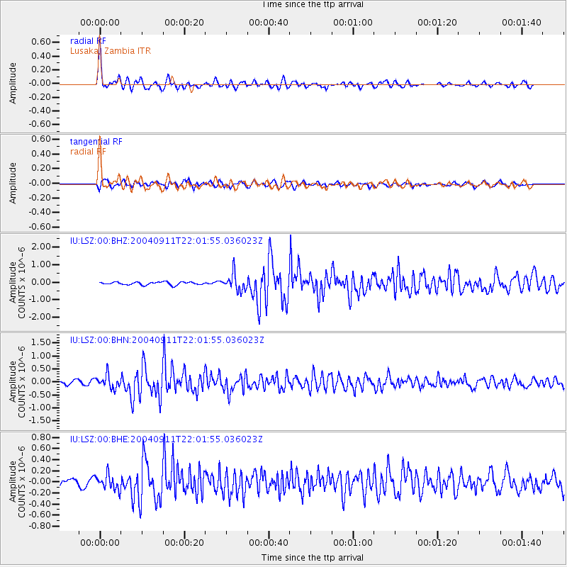
LSZ Lusaka, Zambia - Earthquake Result Viewer

| Earthquake location: |
South Sandwich Islands Region |
| Earthquake latitude/longitude: |
-58.0/-25.3 |
| Earthquake time(UTC): |
2004/09/11 (255) 21:52:38 GMT |
| Earthquake Depth: |
64 km |
| Earthquake Magnitude: |
5.8 MB, 6.1 MW, 6.1 MW |
| Earthquake Catalog/Contributor: |
WHDF/NEIC |
|
| Network: |
IU Global Seismograph Network (GSN - IRIS/USGS) |
| Station: |
LSZ Lusaka, Zambia |
| Lat/Lon: |
15.28 S/28.19 E |
| Elevation: |
1184 m |
|
| Distance: |
58.2 deg |
| Az: |
65.977 deg |
| Baz: |
210.283 deg |
| Ray Param: |
0.06284815 |
| Estimated Moho Depth: |
43.5 km |
| Estimated Crust Vp/Vs: |
1.60 |
| Assumed Crust Vp: |
6.642 km/s |
| Estimated Crust Vs: |
4.151 km/s |
| Estimated Crust Poisson's Ratio: |
0.18 |
|
| Radial Match: |
90.26103 % |
| Radial Bump: |
400 |
| Transverse Match: |
72.178764 % |
| Transverse Bump: |
400 |
| SOD ConfigId: |
2459 |
| Insert Time: |
2010-03-02 15:23:49.814 +0000 |
| GWidth: |
2.5 |
| Max Bumps: |
400 |
| Tol: |
0.001 |
|
Signal To Noise
| Channel | StoN | STA | LTA |
| IU:LSZ:00:BHN:20040911T22:01:55.036023Z | 3.9582307 | 2.4941835E-7 | 6.3012585E-8 |
| IU:LSZ:00:BHE:20040911T22:01:55.036023Z | 1.7781291 | 1.3444726E-7 | 7.561164E-8 |
| IU:LSZ:00:BHZ:20040911T22:01:55.036023Z | 5.8845587 | 4.859663E-7 | 8.2583306E-8 |
| Arrivals |
| Ps | 4.2 SECOND |
| PpPs | 16 SECOND |
| PsPs/PpSs | 20 SECOND |


