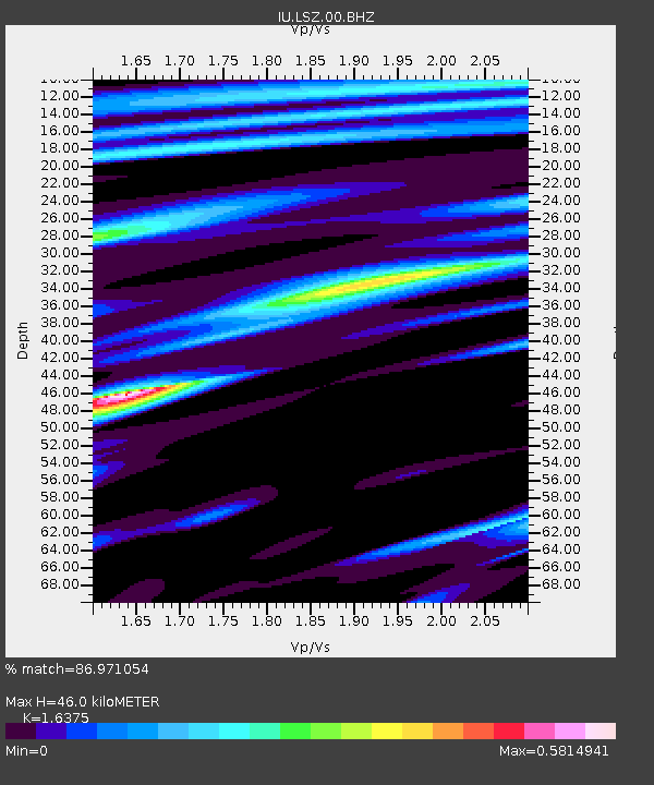
LSZ Lusaka, Zambia - Earthquake Result Viewer
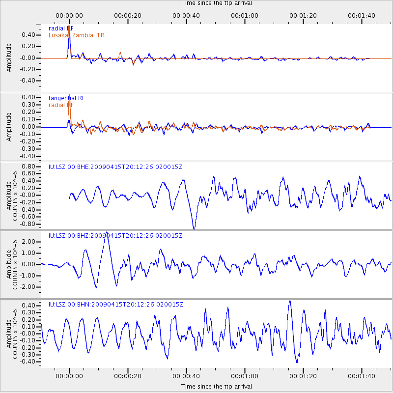
Earthquake location: Southern Sumatra, Indonesia
Earthquake latitude/longitude: -3.1/100.5
Earthquake time(UTC): 2009/04/15 (105) 20:01:34 GMT
Earthquake Depth: 20 km
Earthquake Magnitude: 6.1 MB, 6.4 MS, 6.4 MW, 6.2 MW
Earthquake Catalog/Contributor: WHDF/NEIC
Network: IU Global Seismograph Network (GSN - IRIS/USGS)
Station: LSZ Lusaka, Zambia
Lat/Lon: 15.28 S/28.19 E
Elevation: 1200 m
Distance: 72.1 deg
Az: 255.042 deg
Baz: 88.347 deg
Ray Param: 0.053869564
Estimated Moho Depth: 46.0 km
Estimated Crust Vp/Vs: 1.64
Assumed Crust Vp: 6.642 km/s
Estimated Crust Vs: 4.056 km/s
Estimated Crust Poisson's Ratio: 0.20
Radial Match: 86.971054 %
Radial Bump: 400
Transverse Match: 72.18846 %
Transverse Bump: 400
SOD ConfigId: 2658
Insert Time: 2010-03-02 15:24:00.291 +0000
GWidth: 2.5
Max Bumps: 400
Tol: 0.001

Signal To Noise

ChannelStoNSTALTA
IU:LSZ:00:BHZ:20090415T20:12:26.020015Z4.3497045.9822816E-71.3753308E-7
IU:LSZ:00:BHN:20090415T20:12:26.020015Z1.45754171.5829289E-71.0860265E-7
IU:LSZ:00:BHE:20090415T20:12:26.020015Z2.01241762.539078E-71.2617055E-7
Arrivals
Ps4.6 SECOND
PpPs18 SECOND
PsPs/PpSs22 SECOND